IMAGES TAKEN NEAR TO
Mount Road, LEICESTER, LE5 3DN
Introduction
This page details the photographs taken nearby to Mount Road, LE5 3DN by members of the Geograph project.
The Geograph project started in 2005 with the aim of publishing, organising and preserving representative images for every square kilometre of Great Britain, Ireland and the Isle of Man.

There are currently over 7.5m images from over14,400 individuals and you can help contribute to the project by visiting https://www.geograph.org.uk
Image Map
Images are licensed for reuse under creativecommons.org/licenses/by-sa/2.0
Notes
- Clicking on the map will re-center to the selected point.
- The higher the marker number, the further away the image location is from the centre of the postcode.
Image Listing (49 Images Found)
Images are licensed for reuse under creativecommons.org/licenses/by-sa/2.0
Image
Details
Distance
1
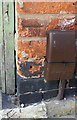
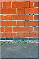
Benchmark on #66 Grove Road
Ordnance Survey cut mark benchmark described on the Bench Mark Database at https://www.bench-marks.org.uk/bm84278
Image: © Roger Templeman
Taken: 4 May 2017
0.03 miles
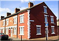
2
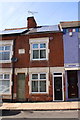
#66 Grove Road
There is an OS benchmark Image in the bricks right of the wooden gate. The date stone above the gate reads Wigston Houses 1889
Image: © Roger Templeman
Taken: 4 May 2017
0.03 miles
3
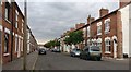
Sherrard Road in Spinney Hills, Leicester
Image: © Mat Fascione
Taken: 17 Jul 2018
0.04 miles
5
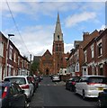
Frederick Road in Spinney Hills, Leicester
Spinney Hills is an inner city area of Leicester. St Saviour's Church is a large Grade II listed, Victorian Gothic Church designed by Sir George Gilbert Scott, built in 1875‐77. The church closed in 2006 and is currently up for sale.
Image: © Mat Fascione
Taken: 30 Jul 2019
0.06 miles
6
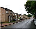
Houses at Grove Road / Vulcan Road junction
Image: © Roger Templeman
Taken: 4 May 2017
0.06 miles
7
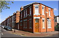
Houses on Sherrard Road at Vulcan Road junction
There is an OS benchmark Image at the right end of the right hand face of the house at the corner
Image: © Roger Templeman
Taken: 4 May 2017
0.08 miles
8
Benchmark on #1 Sherrard Road (Vulcan Road face)
Ordnance Survey cut mark benchmark described on the Bench Mark Database at https://www.bench-marks.org.uk/bm84277
Image: © Roger Templeman
Taken: 4 May 2017
0.09 miles
9

St Saviours Church, St Saviours Road
Image: © Roger Templeman
Taken: 4 May 2017
0.11 miles
10
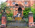
Gateway to redundant church dedicated to St Saviour
The church dedicated to St Saviour was built to the design of Gilbert Scott from 1875 to 1878 and was the largest Victorian church in Leicester capable of holding a congregation of 1000. It was declared redundant and now appears to be sinking into dereliction although the skip may indicate otherwise. It is listed by English Heritage as being at risk.
Image: © Andrew Tatlow
Taken: 13 Aug 2010
0.11 miles