IMAGES TAKEN NEAR TO
Humberstone Road, LEICESTER, LE5 0AE
Introduction
This page details the photographs taken nearby to Humberstone Road, LE5 0AE by members of the Geograph project.
The Geograph project started in 2005 with the aim of publishing, organising and preserving representative images for every square kilometre of Great Britain, Ireland and the Isle of Man.

There are currently over 7.5m images from over14,400 individuals and you can help contribute to the project by visiting https://www.geograph.org.uk
Image Map
Images are licensed for reuse under creativecommons.org/licenses/by-sa/2.0
Notes
- Clicking on the map will re-center to the selected point.
- The higher the marker number, the further away the image location is from the centre of the postcode.
Image Listing (165 Images Found)
Images are licensed for reuse under creativecommons.org/licenses/by-sa/2.0
Image
Details
Distance
1
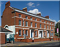
Spa Place, Humberstone Road, Leicester
Plain four-house terrace of 1790-1800. The central pair of houses share a semi-circular porch. Grade II listed.
The name derives from a short-lived spa on the site.
Image: © Stephen Richards
Taken: 24 Aug 2011
0.01 miles
2
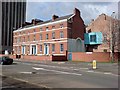
Bray and Bray solicitors, at the end of Humberstone Road
The white plaque visible on the far left of the front of the building celebrates Queen Victoria's 60th Jubilee, and is shown in detail here Image
Image: © Keith Williams
Taken: 27 Mar 2008
0.02 miles
3
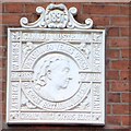
Plaque on the front of Bray and Bray Solicitors
This plaque is located on the extreme left of the frontage of the building. Its position can be seen here Image
Image: © Keith Williams
Taken: 27 Mar 2008
0.02 miles
4
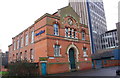
Former Zion Chapel, Eskine Street
There is an OS benchmark Image on the near corner of the building (now the offices of Bray & Bray Solicitors) right of the blue gate
Image: © Roger Templeman
Taken: 3 Jan 2015
0.02 miles
5
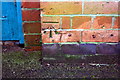
Benchmark on former Zion Chapel, Erskine Street
Ordnance Survey cut mark benchmark described on the Bench Mark Database at http://www.bench-marks.org.uk/bm63439
Image: © Roger Templeman
Taken: 3 Jan 2015
0.03 miles
6
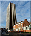
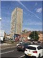
Cardinal Telephone Exchange Tower
Along Humberstone Road in Leicester. The tower block is the tallest building in Leicester, it is 17 floors and 84 metres in height.
Image: © Mat Fascione
Taken: 7 Dec 2013
0.03 miles
7
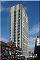
Cardinal Telephone Exchange, Humberstone Road, Leicester (1)
At a little over 275 feet, the city's tallest building, its height accentuated by its slender form and close-set vertical fins.
Another view here: Image
Image: © Stephen Richards
Taken: 23 Aug 2011
0.04 miles
8
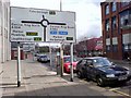
The end of Humberstone Road
The roundabout is on the ring road, and is the junction between St Matthew's Way and St George's Way.
Image: © Keith Williams
Taken: 27 Mar 2008
0.04 miles
10
Buildings by St Matthew's Way, Leicester
Image: © David Howard
Taken: 5 Jun 2022
0.04 miles