IMAGES TAKEN NEAR TO
Dundonald Road, LEICESTER, LE4 5GD
Introduction
This page details the photographs taken nearby to Dundonald Road, LE4 5GD by members of the Geograph project.
The Geograph project started in 2005 with the aim of publishing, organising and preserving representative images for every square kilometre of Great Britain, Ireland and the Isle of Man.

There are currently over 7.5m images from over14,400 individuals and you can help contribute to the project by visiting https://www.geograph.org.uk
Image Map
Images are licensed for reuse under creativecommons.org/licenses/by-sa/2.0
Notes
- Clicking on the map will re-center to the selected point.
- The higher the marker number, the further away the image location is from the centre of the postcode.
Image Listing (175 Images Found)
Images are licensed for reuse under creativecommons.org/licenses/by-sa/2.0
Image
Details
Distance
1
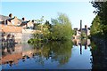
Grand Union Canal - Leicester
A view of the canal in October 2011, compare to November 2010. Image]
Image: © Ashley Dace
Taken: Unknown
0.07 miles
2

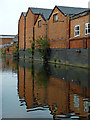
Grand Union Canal - Leicester
Canalside housing next to the canal.
Image: © Ashley Dace
Taken: Unknown
0.07 miles
3

Grand Union Canal in Leicester
The brick wall on the right belong to some terrace houses along Marjorie Street.
Image: © Mat Fascione
Taken: 23 Nov 2013
0.08 miles
4

Grand Union Canal - Leicester
A shady spot on the towpath.
Image: © Ashley Dace
Taken: Unknown
0.09 miles
5
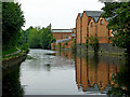
Grand Union Canal/Soar Navigation in Leicester
This is a canalised section of the Grand Union Canal/Soar Navigation north of Limekiln Lock, No 43. The canal is level with the nearby River Soar (off to the left past Frog Island) so is prone to slight flooding when the river is high. Drainage is over the weir by Belgrave Lock.
On the right are industrial buildings and the back yards of some terraced housing in Marjorie Street.
Image: © Roger Kidd
Taken: 25 Aug 2013
0.09 miles
6
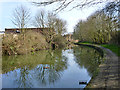
Grand Union Canal (Leicester Line), Leicester
The pound above a lock out of the River Soar, which is rejoined a further two locks later.
Image: © Robin Webster
Taken: 25 Mar 2016
0.09 miles
7
Canalside industry in Leicester
This is a canalised section of the Grand Union Canal/Soar Navigation north of Limekiln Lock, No 43. The canal is level with the nearby River Soar (off to the left past Frog Island) so is prone to slight flooding when the river is high. Drainage is over the weir by Belgrave Lock.
On the right are industrial buildings which have frontages in Marjorie Street.
Image: © Roger Kidd
Taken: 25 Aug 2013
0.10 miles
8
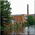
Grand Union Canal in Leicester
This image is by the Grand Union Canal/Soar Navigation below Lime Kiln Lock and Bridge No 9. This section is level with the nearby River Soar (off to the right past Frog Island) so is prone to slight flooding when the river is high. There are back gardens and factories on the left (in Marjorie Street). The chimney is part of the former Abbey Mill, now converted into living accommodation.
Image: © Roger Kidd
Taken: 25 Aug 2013
0.10 miles
9
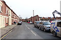
Marjorie Street in Belgrave, Leicester
On the right is the demolition of some factories which were destroyed by a massive fire on the 28th December 2015. The windows of the terraced houses on the left have been boarded up after being damaged by the heat of the fire.
Image: © Mat Fascione
Taken: 1 Jan 2016
0.10 miles
10
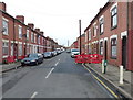
Marjorie Street in Belgrave, Leicester
Image: © Mat Fascione
Taken: 1 Jan 2016
0.10 miles