IMAGES TAKEN NEAR TO
Glebelands Road, LEICESTER, LE4 2WB
Introduction
This page details the photographs taken nearby to Glebelands Road, LE4 2WB by members of the Geograph project.
The Geograph project started in 2005 with the aim of publishing, organising and preserving representative images for every square kilometre of Great Britain, Ireland and the Isle of Man.

There are currently over 7.5m images from over14,400 individuals and you can help contribute to the project by visiting https://www.geograph.org.uk
Image Map
Images are licensed for reuse under creativecommons.org/licenses/by-sa/2.0
Notes
- Clicking on the map will re-center to the selected point.
- The higher the marker number, the further away the image location is from the centre of the postcode.
Image Listing (19 Images Found)
Images are licensed for reuse under creativecommons.org/licenses/by-sa/2.0
Image
Details
Distance
1
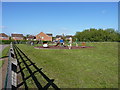
Children's play area
Right opposite the gates of the Glebelands Primary School.
Image: © Richard Law
Taken: 22 May 2013
0.03 miles
2
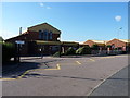
Glebelands Primary School
Opened in 1997, the school mainly serves the Glebelands estate and the nearby Thurcaston Park. http://www.glebelands.leicester.sch.uk/default.htm
Image: © Richard Law
Taken: 22 May 2013
0.05 miles
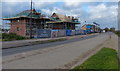
4
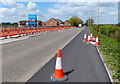
Construction work along Leicester Road in Thurcaston
Image, same view taken 7 months later.
Image: © Mat Fascione
Taken: 22 Apr 2017
0.11 miles
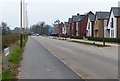
5
New houses along Leicester Road
A new housing development called Glebelands Park, on the northern edge of Leicester city.
Image, same view taken 7 months earlier.
Image: © Mat Fascione
Taken: 23 Nov 2017
0.12 miles
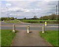
7
The junction of Greengate Lane with Leicester Road and Beaumont Leys Lane
Image: © Tim Glover
Taken: 4 May 2015
0.18 miles
8
Greengate Lane near Leicester
The junction of Beaumont Leys Lane and Greengate Lane.
Image: © Mat Fascione
Taken: 5 Apr 2007
0.18 miles
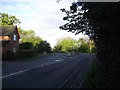
9
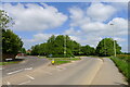
Approaching a roundabout at Ashton Green
"Ashton Green is a major 130 ha (321-acre) sustainable urban extension for Leicester. A housing-led mixed-use development of up to 3,000 homes and 10 ha (24.7 acres) of employment land is well underway ... " https://www.visitleicester.info/invest/sites-properties/ashton-green
Image: © Tim Heaton
Taken: 25 May 2023
0.18 miles
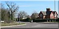
10
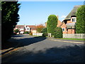
Hogarth Road, near Thurcaston
Modern green belt housing off Leicester Road between Birstall and the village of Thurcaston showing the junction of Hogarth Road and Bevan Road. There is a similar development about half a mile to the south with a Bevan Road which also ends abruptly in a field; obvious intentions to join the two together at some point.
Image: © Kate Jewell
Taken: 27 Oct 2005
0.19 miles