IMAGES TAKEN NEAR TO
Anstey Lane, LEICESTER, LE4 0FB
Introduction
This page details the photographs taken nearby to Anstey Lane, LE4 0FB by members of the Geograph project.
The Geograph project started in 2005 with the aim of publishing, organising and preserving representative images for every square kilometre of Great Britain, Ireland and the Isle of Man.

There are currently over 7.5m images from over14,400 individuals and you can help contribute to the project by visiting https://www.geograph.org.uk
Image Map
Images are licensed for reuse under creativecommons.org/licenses/by-sa/2.0
Notes
- Clicking on the map will re-center to the selected point.
- The higher the marker number, the further away the image location is from the centre of the postcode.
Image Listing (18 Images Found)
Images are licensed for reuse under creativecommons.org/licenses/by-sa/2.0
Image
Details
Distance
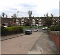
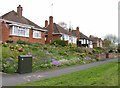
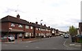
2
Buckminster Road, Leicester
Typical street for this square
Image: © Kate Jewell
Taken: 7 Nov 2005
0.10 miles
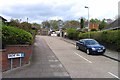
3
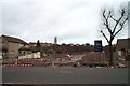
Site of Marconi after demolition.
The old Marconi site prior to redevelopment.
Photo taken 13th Feb 2002.
Image: © Clive Cartwright
Taken: 3 Jun 1999
0.13 miles
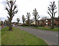
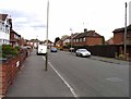
6
Courtenay Road/Whitwick Way junction, Leicester
Image: © Mat Fascione
Taken: 29 Nov 2019
0.14 miles
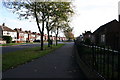
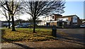
8
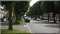
Anstey Lane, looking east
Viewed from Jean Drive
Image: © John Welford
Taken: 7 Jun 2016
0.16 miles