IMAGES TAKEN NEAR TO
Danvers Road, LEICESTER, LE3 2AB
Introduction
This page details the photographs taken nearby to Danvers Road, LE3 2AB by members of the Geograph project.
The Geograph project started in 2005 with the aim of publishing, organising and preserving representative images for every square kilometre of Great Britain, Ireland and the Isle of Man.

There are currently over 7.5m images from over14,400 individuals and you can help contribute to the project by visiting https://www.geograph.org.uk
Image Map
Images are licensed for reuse under creativecommons.org/licenses/by-sa/2.0
Notes
- Clicking on the map will re-center to the selected point.
- The higher the marker number, the further away the image location is from the centre of the postcode.
Image Listing (168 Images Found)
Images are licensed for reuse under creativecommons.org/licenses/by-sa/2.0
Image
Details
Distance
1
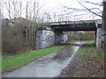
Great Central Way
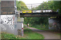
At this point the Great Central Way, following the trackbed of the old Great Central Railway, passes under the Leicester - Coalville line. The cutting has been partially infilled creating a nasty incline for the participants in the Leicester Marathon in the latter stages of the event. The Great Central was once an important main line between London and Sheffield, but trains ceased to run here in 1969 after a lengthy period of decline; in the latter years traffic consisted only of a sporadic local passenger service between Nottingham and Rugby. The railway across the top, however, is still in use, albeit nowadays only for freight.
Image: © Stephen McKay
Taken: 14 Oct 2007
0.03 miles
2
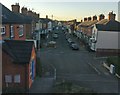
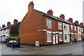
Danvers Road in the West End area of Leicester
Image: © Mat Fascione
Taken: 5 Jan 2017
0.05 miles
3
Great Central Way, Leicester
A view south along the Great Central Way. Although the path follows the route of the former Great Central Railway, at this pointit is at a higher level than the railway tracks were.
Image: © Malc McDonald
Taken: 27 Feb 2011
0.05 miles
4
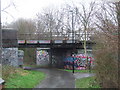
Great Central Way, Leicester
The Great Central Way is a shared footpath and cycle path in Leicester, using the route of the former Great Central Railway. Here it passes beneath another railway line. However, the path rises up a slope here (towards the camera), to pass alongside buildings which have been built on the former railway.
Image: © Malc McDonald
Taken: 27 Feb 2011
0.05 miles
5
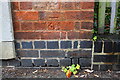
Damaged benchmark on #46 Lambert Road
Ordnance Survey cut mark benchmark described on the Bench Mark Database at https://www.bench-marks.org.uk/bm99517
Image: © Roger Templeman
Taken: 11 Sep 2018
0.05 miles
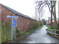
6
Houses at the Lambert Road / Wolverton Road junction
There is an OS benchmark Image on the near corner, right hand face, of the nearest house
Image: © Roger Templeman
Taken: 11 Sep 2018
0.05 miles
7
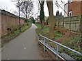
Great Central Way in Leicester
A cycleway and footpath that follows the route of the former Great Central Railway.
Image: © Mat Fascione
Taken: 10 Mar 2017
0.06 miles
8
Great Central Way, Leicester
This path now occupies the route of the Great Central Railway through part of Leicester. The railway closed in 1969.
Here the path passes beneath another railway line. As it does so, it climbs a slope and bends round to the right, to pass alongside buildings which now occupy the former railway. To the left, behind the trees, you can just about make out the level of the railway tracks.
Image: © Malc McDonald
Taken: 27 Feb 2011
0.06 miles
9
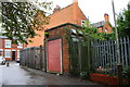
Electricity substation beside lane approaching Raymond Road
There is an OS benchmark Image on the bricks on the near side of the substation door
Image: © Roger Templeman
Taken: 11 Sep 2018
0.07 miles
10
Benchmark on old electricity substation beside lane off Raymond Road
Ordnance Survey cut mark benchmark described on the Bench Mark Database at https://www.bench-marks.org.uk/bm99516
Image: © Roger Templeman
Taken: 11 Sep 2018
0.07 miles