IMAGES TAKEN NEAR TO
Hillsborough Close, LEICESTER, LE2 9QQ
Introduction
This page details the photographs taken nearby to Hillsborough Close, LE2 9QQ by members of the Geograph project.
The Geograph project started in 2005 with the aim of publishing, organising and preserving representative images for every square kilometre of Great Britain, Ireland and the Isle of Man.

There are currently over 7.5m images from over14,400 individuals and you can help contribute to the project by visiting https://www.geograph.org.uk
Image Map
Images are licensed for reuse under creativecommons.org/licenses/by-sa/2.0
Notes
- Clicking on the map will re-center to the selected point.
- The higher the marker number, the further away the image location is from the centre of the postcode.
Image Listing (7 Images Found)
Images are licensed for reuse under creativecommons.org/licenses/by-sa/2.0
Image
Details
Distance

2
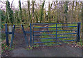
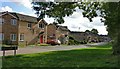
Entrance to Grange Spinney
On Ambleside Way in Eyres Monsell, this small area of woodland is completely surrounded by housing.
The Spinney probably gets it name from Aylestone Grange, which before the Eyres Monsell housing estate was built, was 300 metres north of here.
Image: © Mat Fascione
Taken: 2 Feb 2014
0.21 miles
3
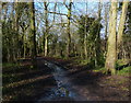
Grange Spinney in Eyres Monsell
This small area of woodland is completely surrounded by housing.
The Spinney probably gets it name from Aylestone Grange, which before the Eyres Monsell housing estate was built, was 300 metres north of here.
Image: © Mat Fascione
Taken: 2 Feb 2014
0.22 miles
4
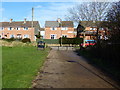
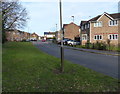
Houses on Featherstone Drive
In Glen Parva, Leicester.
Image: © Mat Fascione
Taken: 2 Feb 2014
0.23 miles
6
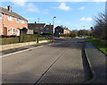
Ambleside Way in Eyres Monsell, Leicester
Image: © Mat Fascione
Taken: 28 Sep 2017
0.24 miles