IMAGES TAKEN NEAR TO
Burnmoor Street, LEICESTER, LE2 7JJ
Introduction
This page details the photographs taken nearby to Burnmoor Street, LE2 7JJ by members of the Geograph project.
The Geograph project started in 2005 with the aim of publishing, organising and preserving representative images for every square kilometre of Great Britain, Ireland and the Isle of Man.

There are currently over 7.5m images from over14,400 individuals and you can help contribute to the project by visiting https://www.geograph.org.uk
Image Map
Images are licensed for reuse under creativecommons.org/licenses/by-sa/2.0
Notes
- Clicking on the map will re-center to the selected point.
- The higher the marker number, the further away the image location is from the centre of the postcode.
Image Listing (201 Images Found)
Images are licensed for reuse under creativecommons.org/licenses/by-sa/2.0
Image
Details
Distance
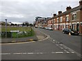
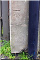
1
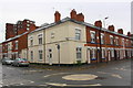
Houses at the junction of Filbert Street and Burnmoor Street
There is an Ordnance Survey benchmark Image on the near corner, left hand face, of the nearest house
Image: © phil Richards
Taken: 16 Jun 2017
0.04 miles
2
Benchmark on No. 112 Filbert Street
Ordnance Survey cut mark benchmark described on the Bench Mark Database at www.bench-marks.org.uk/bm85195
Image: © phil Richards
Taken: 16 Jun 2017
0.04 miles
3
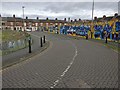
Lineker Road in Leicester
This is the site of the former Filbert Street football stadium, which served as the home of Leicester City FC from 1891 until 2002. The stadium was demolished in 2003.
Lineker Road is now covered in graffiti and run down, Gary would be proud!
The houses in the distance are on Filbert Street.
Image: © Mat Fascione
Taken: 20 Feb 2017
0.06 miles
4
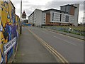
Lineker Road in Leicester
This is the site of the former Filbert Street football stadium, which served as the home of Leicester City FC from 1891 until 2002. The stadium was demolished in 2003.
Up ahead is the Filbert Village development, built as accommodation for students for the nearby De Montfort University and University of Leicester.
Lineker Road is now covered in graffiti and run down, Gary would be proud!
Image: © Mat Fascione
Taken: 20 Feb 2017
0.06 miles
5
Junction of Lineker Road and Filbert Street
Lineker Road is on the site of the former Filbert Street football stadium, which served as the home of Leicester City FC from 1891 until 2002. The stadium was demolished in 2003.
Image: © Mat Fascione
Taken: 20 Feb 2017
0.06 miles
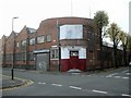
6
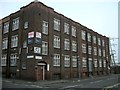
Leicester-Saint Mary's Works
Industrial premises at the corner of Burnmoor Street and Brazil Street.
Image: © Ian Rob
Taken: 19 Nov 2011
0.06 miles
7
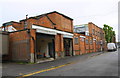
Asiana Cash & Carry warehouse, Brazil Street
There is an Ordnance Survey benchmark Image on the concrete blocks at the bottom of the front corner of the nearest loading bay, next to the black downpipe
Image: © phil Richards
Taken: 16 Jun 2017
0.07 miles
8
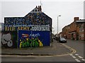
Mural on Burnmoor Street, Leicester
To celebrate Leicester City winning the 2015/16 Premier League title.
Image: © Mat Fascione
Taken: 6 Feb 2017
0.07 miles
9
Benchmark on warehouse on south side of Brazil Street
Ordnance Survey cut mark benchmark described on the Bench Mark Database at www.bench-marks.org.uk/bm85301
Image: © phil Richards
Taken: 16 Jun 2017
0.07 miles
10
Leicester-New Bridge Street
Industrial premises on the corner of Sawday Street.
Image: © Ian Rob
Taken: 19 Nov 2011
0.07 miles