IMAGES TAKEN NEAR TO
Cairngorm Close, LEICESTER, LE2 6RJ
Introduction
This page details the photographs taken nearby to Cairngorm Close, LE2 6RJ by members of the Geograph project.
The Geograph project started in 2005 with the aim of publishing, organising and preserving representative images for every square kilometre of Great Britain, Ireland and the Isle of Man.

There are currently over 7.5m images from over14,400 individuals and you can help contribute to the project by visiting https://www.geograph.org.uk
Image Map
Images are licensed for reuse under creativecommons.org/licenses/by-sa/2.0
Notes
- Clicking on the map will re-center to the selected point.
- The higher the marker number, the further away the image location is from the centre of the postcode.
Image Listing (58 Images Found)
Images are licensed for reuse under creativecommons.org/licenses/by-sa/2.0
Image
Details
Distance
1
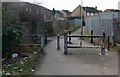
Alleyway to Grampian Close
Complete with the usual litter and graffiti! A footpath travels from here across the Wash Brook Nature Park, and on to Knighton Lane East.
Image: © Mat Fascione
Taken: 1 Mar 2009
0.05 miles
2
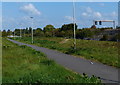
Path to Knighton Lane East
This path runs from Grampian Close, under the Midland Mainline bridge and across Wash Brook Nature Park, past the Sir Jonathan North Community College, and onto Knighton Lane East.
Image: © Mat Fascione
Taken: 21 Sep 2014
0.05 miles
3
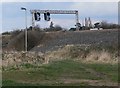
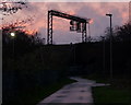
Gantry across the Midland Mainline
This railway embankment effectively marks the boundary of Aylestone Park to the west and Knighton Fields to the east.
Image: © Mat Fascione
Taken: 1 Mar 2009
0.08 miles
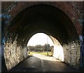
6
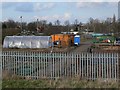
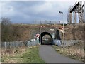
Footpath under the Midland Mainline
This path runs from Grampian Close, under this bridge and across Wash Brook Nature Park, past the Sir Jonathan North Community College, and onto Knighton Lane East.
Image, identical view taken over eight years earlier.
Image: © Mat Fascione
Taken: 17 Jun 2017
0.09 miles
7
Gantry along the Midland Main Line
The path runs from Grampian Close, under the Midland Mainline via a tunnel, and across Wash Brook Nature Park, past the Sir Jonathan North Community College, and onto Knighton Lane East.
Image: © Mat Fascione
Taken: 21 Dec 2013
0.10 miles
8
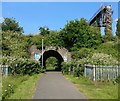
Footpath under the Midland Mainline
This path runs from Grampian Close, under this bridge and across Wash Brook Nature Park, past the Sir Jonathan North Community College, and onto Knighton Lane East.
Image, identical view taken over eight years later.
Image: © Mat Fascione
Taken: 1 Mar 2009
0.10 miles
9
Through the arch
This path runs from Grampian Close, under this Midland Mainline bridge and across Wash Brook Nature Park, past the Sir Jonathan North Community College, and onto Knighton Lane East.
Image: © Mat Fascione
Taken: 1 Mar 2009
0.11 miles
10
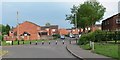
Heathcott Road, Leicester
I guess this is to stop the boy racers.
Image: © Mat Fascione
Taken: 3 Jun 2007
0.13 miles