IMAGES TAKEN NEAR TO
Churchill Close, LEICESTER, LE2 5AP
Introduction
This page details the photographs taken nearby to Churchill Close, LE2 5AP by members of the Geograph project.
The Geograph project started in 2005 with the aim of publishing, organising and preserving representative images for every square kilometre of Great Britain, Ireland and the Isle of Man.

There are currently over 7.5m images from over14,400 individuals and you can help contribute to the project by visiting https://www.geograph.org.uk
Image Map
Images are licensed for reuse under creativecommons.org/licenses/by-sa/2.0
Notes
- Clicking on the map will re-center to the selected point.
- The higher the marker number, the further away the image location is from the centre of the postcode.
Image Listing (62 Images Found)
Images are licensed for reuse under creativecommons.org/licenses/by-sa/2.0
Image
Details
Distance
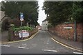
1
Oadby, Leics LE2
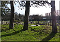
Although some street plans continue to show the local library as being adjacent to the large public car park at the closed end of Sandhurst Street (a cul-de-sac), in what has now become a community centre, the library has evidently transferred to this new building on Leicester Road. This is the view towards St Peter's Church where Leicester Road joins London Road (the B5403).
Image: © David Hallam-Jones
Taken: 7 Jan 2013
0.04 miles
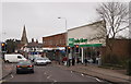
2
Oadby, Leics LE2
Two churches are situated on this stretch of Leicester Road. Beyond the parked cars is the entrance to Oadby Baptist Church and in the distance, St Peter's Church at the junction of Leicester Road and London Road (the B5403).
Image: © David Hallam-Jones
Taken: 7 Jan 2013
0.06 miles
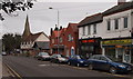
3
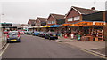
Oadby, Leics LE2
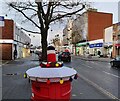
The cluster of shops at the junction of Chestnut Avenue, where The Parade joins Leicester Road.
Image: © David Hallam-Jones
Taken: 7 Jan 2013
0.06 miles
6
St Peter's Church, Oadby
Looking along Wigston Road.
Image: © Mat Fascione
Taken: 3 Jun 2007
0.10 miles
7
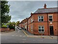
Junction of Church Street and London Road, Oadby
Mainly late Victorian terraced houses on Church Street. London Road was 'Main Street' through the middle of the village of Oadby in Victorian times, and the main road in to Leicester from the south-east. The 'village' is now bisected by the A6 dual carriageway.
Image: © Tim Heaton
Taken: 4 Oct 2022
0.10 miles
8
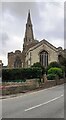
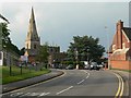
St Peter's Church from Leicester Road
The church spire is an Ordnance Survey intersected station trig point, http://trigpointing.uk/trig/19855
Image: © Roger Templeman
Taken: 26 May 2022
0.10 miles
9
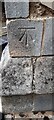
Benchmark on buttress on NW corner of St Peter's Church
Ordnance Survey cut mark benchmark levelled at 99.517m above Newlyn Datum in 1965
Image: © Roger Templeman
Taken: 26 May 2022
0.10 miles