IMAGES TAKEN NEAR TO
Eastcourt Road, LEICESTER, LE2 3YA
Introduction
This page details the photographs taken nearby to Eastcourt Road, LE2 3YA by members of the Geograph project.
The Geograph project started in 2005 with the aim of publishing, organising and preserving representative images for every square kilometre of Great Britain, Ireland and the Isle of Man.

There are currently over 7.5m images from over14,400 individuals and you can help contribute to the project by visiting https://www.geograph.org.uk
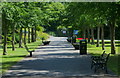
Image Map
Images are licensed for reuse under creativecommons.org/licenses/by-sa/2.0
Notes
- Clicking on the map will re-center to the selected point.
- The higher the marker number, the further away the image location is from the centre of the postcode.
Image Listing (29 Images Found)
Images are licensed for reuse under creativecommons.org/licenses/by-sa/2.0
Image
Details
Distance
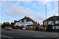
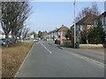
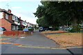
1
Kingsmead Close, Knighton
Running parallel to Palmerston Way without any access to it.
Image: © David Howard
Taken: 2 Aug 2022
0.03 miles
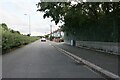
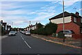
3

Palmerston Way, Leicester
Looking towards Kingsmead Close running parallel.
Image: © David Howard
Taken: 28 Apr 2024
0.07 miles
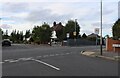
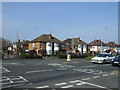
9
Welford Road, Knighton
At the corner of Westgate Road
Image: © David Howard
Taken: 2 Aug 2022
0.15 miles