IMAGES TAKEN NEAR TO
Meadvale Road, LEICESTER, LE2 3WJ
Introduction
This page details the photographs taken nearby to Meadvale Road, LE2 3WJ by members of the Geograph project.
The Geograph project started in 2005 with the aim of publishing, organising and preserving representative images for every square kilometre of Great Britain, Ireland and the Isle of Man.

There are currently over 7.5m images from over14,400 individuals and you can help contribute to the project by visiting https://www.geograph.org.uk
Image Map
Images are licensed for reuse under creativecommons.org/licenses/by-sa/2.0
Notes
- Clicking on the map will re-center to the selected point.
- The higher the marker number, the further away the image location is from the centre of the postcode.
Image Listing (45 Images Found)
Images are licensed for reuse under creativecommons.org/licenses/by-sa/2.0
Image
Details
Distance
4
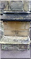
Benchmark on buttress on west angle of St Mary Magdalene's Church
Ordnance Survey cut mark benchmark described on the Bench Mark Database at www.bench-marks.org.uk/bm46656
Image: © Rob Woodall
Taken: 29 Jun 2020
0.10 miles
5
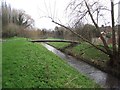
St Mary's footbridge crosses the Wash Brook
A plaque on the stones to the left records that the bridge was opened by the Lord Mayor of Leicester, Councillor Albert Watson, on 6th March 1979.
Image: © Tim Glover
Taken: 2 Jan 2016
0.10 miles
6
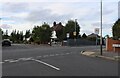
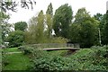
Kingsmead Road, Knighton
The footbridge is crossing The Wash (or Saffron) brook.
Image: © Mat Fascione
Taken: 1 Mar 2009
0.10 miles
7
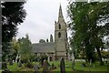
Church of St Mary Magdalen, Knighton, Leicester
13th century origins, largely restored in the 19th century https://historicengland.org.uk/listing/the-list/list-entry/1074020
Image: © Tim Heaton
Taken: 18 Oct 2021
0.10 miles
8
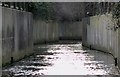
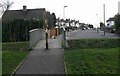
Footbridge over Saffron Brook, Knighton, Leicester
Leading into the Knighton Conservation Area
Image: © Tim Heaton
Taken: 18 Oct 2021
0.10 miles
9
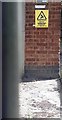
Benchmark and warning sign on Kingsmead Road electricity substation
Ordnance Survey cut mark benchmark described on the Bench Mark Database at www.bench-marks.org.uk/bm127152
Image: © Rob Woodall
Taken: 29 Jun 2020
0.10 miles
10
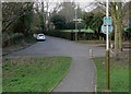
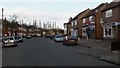
Knighton Village conservation area
Looking towards the southern end of Church Lane.
Image: © Mat Fascione
Taken: 1 Mar 2009
0.10 miles