IMAGES TAKEN NEAR TO
Carisbrooke Avenue, LEICESTER, LE2 3PA
Introduction
This page details the photographs taken nearby to Carisbrooke Avenue, LE2 3PA by members of the Geograph project.
The Geograph project started in 2005 with the aim of publishing, organising and preserving representative images for every square kilometre of Great Britain, Ireland and the Isle of Man.

There are currently over 7.5m images from over14,400 individuals and you can help contribute to the project by visiting https://www.geograph.org.uk
Image Map
Images are licensed for reuse under creativecommons.org/licenses/by-sa/2.0
Notes
- Clicking on the map will re-center to the selected point.
- The higher the marker number, the further away the image location is from the centre of the postcode.
Image Listing (20 Images Found)
Images are licensed for reuse under creativecommons.org/licenses/by-sa/2.0
Image
Details
Distance
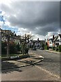
1
Small green space in Knighton
At the junction of Carisbrooke Road and Knighton Church Road.
Image: © Mat Fascione
Taken: 2 Apr 2017
0.08 miles
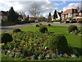
2
Flower bed island, Carisbrooke Road, Leicester
Looking along Knighton Church Road.
Image: © tony ellis
Taken: 5 May 2008
0.08 miles
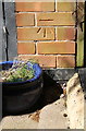
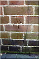
3
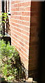
Benchmark on chimney breast of #39 Elms Road
Ordnance Survey cut mark benchmark described on the Bench Mark Database at https://www.bench-marks.org.uk/bm102264
Image: © Roger Templeman
Taken: 8 May 2018
0.12 miles
4
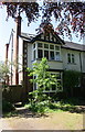
#39 Elms Road
There is an OS benchmark Image on the chimney breast on the left hand side of the house
Image: © Roger Templeman
Taken: 8 May 2018
0.12 miles
5
Benchmark on garage of #65 Elms Road
Ordnance Survey cut mark benchmark described on the Bench Mark Database at https://www.bench-marks.org.uk/bm102321
Image: © Roger Templeman
Taken: 8 May 2018
0.13 miles
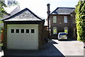
6
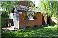
Former garage in garden of #65 Elms Road
There is an OS benchmark Image on the front of the garage on the near side of its doors
Image: © Roger Templeman
Taken: 8 May 2018
0.13 miles
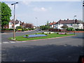
7
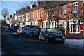
Terraced housing on Knighton Church Road
Christmas Day 2010 and there's still snow on the pavements and in the gardens just south of Leicester city centre.
Knighton Church Road has a good mix of housing styles and sizes from Victorian and Edwardian terraces and villas, through pre and post Second World War semi-detached, to mid 20th century "boxes" with a few 21st century additions.
This is looking west towards Carisbrooke Road.
Image: © Kate Jewell
Taken: 25 Dec 2010
0.16 miles
8
Benchmark on #23 Elms Road
Ordnance Survey cut mark benchmark described on the Bench Mark Database at https://www.bench-marks.org.uk/bm102221
Image: © Roger Templeman
Taken: 8 May 2018
0.17 miles
9
#23 Elms Road
There is an OS benchmark Image on the left hand side of the house near its front corner
Image: © Roger Templeman
Taken: 8 May 2018
0.18 miles