IMAGES TAKEN NEAR TO
Malvern Road, LEICESTER, LE2 2BH
Introduction
This page details the photographs taken nearby to Malvern Road, LE2 2BH by members of the Geograph project.
The Geograph project started in 2005 with the aim of publishing, organising and preserving representative images for every square kilometre of Great Britain, Ireland and the Isle of Man.

There are currently over 7.5m images from over14,400 individuals and you can help contribute to the project by visiting https://www.geograph.org.uk
Image Map
Images are licensed for reuse under creativecommons.org/licenses/by-sa/2.0
Notes
- Clicking on the map will re-center to the selected point.
- The higher the marker number, the further away the image location is from the centre of the postcode.
Image Listing (33 Images Found)
Images are licensed for reuse under creativecommons.org/licenses/by-sa/2.0
Image
Details
Distance
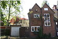
1
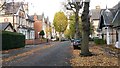
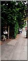
Leafy Leicester
Still a lot of leaves to fall...
Image: © David Martin
Taken: 25 Oct 2014
0.09 miles
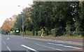
2
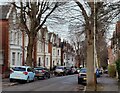
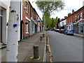
Alexandra Road in Stoneygate, Leicester
Stoneygate is a mainly residential suburb of the city of Leicester, about two miles southeast of the city centre.
Image: © Mat Fascione
Taken: 15 Feb 2021
0.10 miles
6
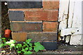
Benchmark on the garage #279 London Road
Ordnance Survey cut mark benchmark described on the Bench Mark Database at https://www.bench-marks.org.uk/bm102219
Image: © Roger Templeman
Taken: 8 May 2018
0.14 miles
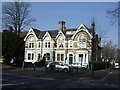
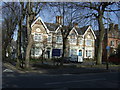
7
Stoneygate Montessori Nursery School, #279 London Road
There is an Ordnance Survey benchmark Image on the school's attached garage on the left hand side of its white doors
Image: © Roger Templeman
Taken: 8 May 2018
0.14 miles
9
Francis Street in Stoneygate, Leicester
Image: © Mat Fascione
Taken: 1 May 2017
0.18 miles
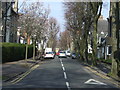
10
Bus shelter on SW side of London Road outside #321
There is a GPO cable marker Image against the low gatepost of #323 London Road near the left hand edge of the image
Image: © Roger Templeman
Taken: 26 May 2022
0.18 miles