IMAGES TAKEN NEAR TO
Knighton Park Road, LEICESTER, LE2 1ZB
Introduction
This page details the photographs taken nearby to Knighton Park Road, LE2 1ZB by members of the Geograph project.
The Geograph project started in 2005 with the aim of publishing, organising and preserving representative images for every square kilometre of Great Britain, Ireland and the Isle of Man.

There are currently over 7.5m images from over14,400 individuals and you can help contribute to the project by visiting https://www.geograph.org.uk
Image Map
Images are licensed for reuse under creativecommons.org/licenses/by-sa/2.0
Notes
- Clicking on the map will re-center to the selected point.
- The higher the marker number, the further away the image location is from the centre of the postcode.
Image Listing (59 Images Found)
Images are licensed for reuse under creativecommons.org/licenses/by-sa/2.0
Image
Details
Distance
1

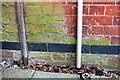
#2 Knighton Park Road
There is an OS benchmark Image on the near corner, left hand face, of the house
Image: © Roger Templeman
Taken: 8 May 2018
0.05 miles
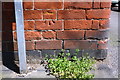
2

Benchmark on #2 Knighton Park Road
Ordnance Survey cut mark benchmark described on the Bench Mark Database at https://www.bench-marks.org.uk/bm99493
Image: © Roger Templeman
Taken: 8 May 2018
0.05 miles
3
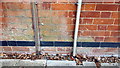
Benchmark on #14 Knighton Park Road
Ordnance Survey cut mark benchmark described on the Bench Mark Database at www.bench-marks.org.uk/bm102217
Image: © Rob Woodall
Taken: 29 Jun 2020
0.06 miles
4
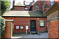
Annex at #14 Knighton Park Road
There is an OS benchmark Image on the wall of the building between the wooden shed and the left hand utility cabinet
Image: © Roger Templeman
Taken: 8 May 2018
0.06 miles
5
Benchmark on #14 Knighton Park Road
Ordnance Survey cut mark benchmark described on the Bench Mark Database at https://www.bench-marks.org.uk/bm102217
Image: © Roger Templeman
Taken: 8 May 2018
0.06 miles
6
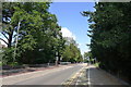
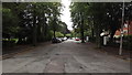
London Road in to Leicester
Cycle Route 63 crosses at the lights, and turns left down Knighton Park Road toward the centre of Leicester
Image: © Tim Heaton
Taken: 13 Aug 2019
0.06 miles
7
Benchmark on the wall of The Avenue at its junction with North Avenue
Ordnance Survey cut mark benchmark described on the Bench Mark Database at https://www.bench-marks.org.uk/bm102218
Image: © Roger Templeman
Taken: 8 May 2018
0.07 miles
8
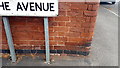
Benchmark on wall of The Avenue at North Avenue junction
Ordnance Survey cut mark benchmark described on the Bench Mark Database at www.bench-marks.org.uk/bm102218
Image: © Rob Woodall
Taken: 29 Jun 2020
0.07 miles
9
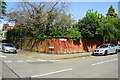
Junction of The Avenue and North Avenue
There is an OS benchmark Image on the wall of The Avenue right of the road name sign
Image: © Roger Templeman
Taken: 8 May 2018
0.07 miles