IMAGES TAKEN NEAR TO
Oxford Road, LEICESTER, LE2 1TN
Introduction
This page details the photographs taken nearby to Oxford Road, LE2 1TN by members of the Geograph project.
The Geograph project started in 2005 with the aim of publishing, organising and preserving representative images for every square kilometre of Great Britain, Ireland and the Isle of Man.

There are currently over 7.5m images from over14,400 individuals and you can help contribute to the project by visiting https://www.geograph.org.uk
Image Map
Images are licensed for reuse under creativecommons.org/licenses/by-sa/2.0
Notes
- Clicking on the map will re-center to the selected point.
- The higher the marker number, the further away the image location is from the centre of the postcode.
Image Listing (62 Images Found)
Images are licensed for reuse under creativecommons.org/licenses/by-sa/2.0
Image
Details
Distance
1
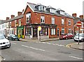
Centre of Balance, 48 Montague Road, Leicester
The Centre of Balance describes itself as a natural health therapy centre. It offers a wide range of therapies including massage therapy, reflexology, herbal medicine, Shiatsu, acupuncture, hypnotherapy, and amongst many others the highly controversial Hopi ear candles procedure. Next door is an antiques shop. In the 1911 census, No. 48 Montague Road was a butcher's shop, run by Thomas Harding, who was resident on the premises.
Image: © P L Chadwick
Taken: 15 Apr 2011
0.04 miles
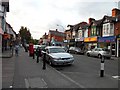
2
Queens Road in Clarendon Park, Leicester
Image: © Mat Fascione
Taken: 5 Mar 2017
0.06 miles
3
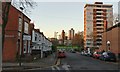
Queens Road, Clarendon Park, Leicester
Trendy area of the city, located to the south of Victoria Park.
Image: © Stephen Sweeney
Taken: 18 Jun 2011
0.06 miles
4
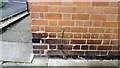
Benchmark of #98 Montague Road (St Leonards Road face)
Ordnance Survey cut mark benchmark described on the Bench Mark Database at www.bench-marks.org.uk/bm127148
Image: © Rob Woodall
Taken: 29 Jun 2020
0.07 miles
5
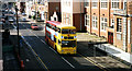
Queens Road, Leicester
Queens Road, Leicester looking towards town centre. 1995, Midland Fox rules the busways.
Image: © Gordon Cragg
Taken: Unknown
0.07 miles
6
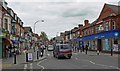
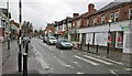
Shops along Queens Road
This popular and busy shopping area is located in the Clarendon Park area of Leicester, viewed from the junction with Montague Road.
Image: © Mat Fascione
Taken: 18 Mar 2008
0.07 miles
7
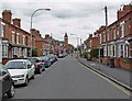
St Leonards Road in Clarendon Park, Leicester
At the junction with Howard Road.
Image: © Mat Fascione
Taken: 3 Dec 2019
0.08 miles
8

St Leonard's Road in Clarendon Park, Leicester
Image: © Mat Fascione
Taken: 20 Nov 2020
0.08 miles
9
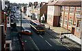
Queens Road, Leicester
Another view of Queens Road, this time with a Citybus in shot.
Image: © Gordon Cragg
Taken: Unknown
0.09 miles
10
Clarendon Park Road, Leicester
The tower of Christchurch Baptist Methodist Church is visible just beyond the junction with Queens Road.
Image: © Mat Fascione
Taken: 18 Mar 2008
0.09 miles