IMAGES TAKEN NEAR TO
Haddon Street, LEICESTER, LE2 0GG
Introduction
This page details the photographs taken nearby to Haddon Street, LE2 0GG by members of the Geograph project.
The Geograph project started in 2005 with the aim of publishing, organising and preserving representative images for every square kilometre of Great Britain, Ireland and the Isle of Man.

There are currently over 7.5m images from over14,400 individuals and you can help contribute to the project by visiting https://www.geograph.org.uk
Image Map
Images are licensed for reuse under creativecommons.org/licenses/by-sa/2.0
Notes
- Clicking on the map will re-center to the selected point.
- The higher the marker number, the further away the image location is from the centre of the postcode.
Image Listing (50 Images Found)
Images are licensed for reuse under creativecommons.org/licenses/by-sa/2.0
Image
Details
Distance
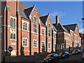
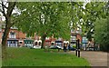
1
Houses at the junction of Mere Road with Buxton Street
There is an OS benchmark Image on the nearest house below the Buxton Street name sign
Image: © Roger Templeman
Taken: 4 May 2017
0.05 miles
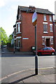
2
Benchmark on #81 Buxton Street
Ordnance Survey cut mark benchmark described on the Bench Mark Database at https://www.bench-marks.org.uk/bm84404
Image: © Roger Templeman
Taken: 4 May 2017
0.05 miles
3
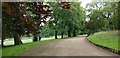
Path through Spinney Hills Park, Leicester
The 34 acres (14 hectares) park was laid out in 1885. It is in the Spinney Hills inner city area of Leicester. This path is at the north-west corner of the park, next to the Mere Road entrance.
Image: © Mat Fascione
Taken: 26 Jun 2019
0.09 miles
4
Path in Spinney Hills Park, Leicester
The 34 acres (14 hectares) park was laid out in 1885. It is in the Spinney Hills inner city area of Leicester. This path is on the north-west corner of the park at Mere Road.
Image: © Mat Fascione
Taken: 26 Jun 2019
0.09 miles
5
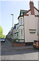
Mere Road houses at Hartington Road junction
Image: © Roger Templeman
Taken: 4 May 2017
0.10 miles
6
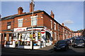
#2 Duffield Street at Melbourne Road junction
There is an OS benchmark Image on the side of the shop near its front corner
Image: © Roger Templeman
Taken: 4 May 2017
0.10 miles
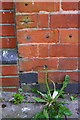
7
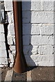
Partly obscured benchmark on #2 Duffield Street
The Ordnance Survey cut mark benchmark which is described on the Bench Mark Database at https://www.bench-marks.org.uk/bm84393 is partly hidden by a cable duct
Image: © Roger Templeman
Taken: 4 May 2017
0.11 miles
8
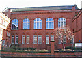
Leicester - Montessori School
On Melbourne Road.
Image: © Dave Bevis
Taken: 16 Feb 2014
0.12 miles
9
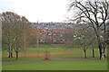
Spinney Hill Park, Leicester
This is the high spot of this ethnically diverse area of Leicester at 80 metres above sea level. It offers welcome visual relief to the narrow streets of terraced housing that make up Spinney Hills. See http://www.leicester.gov.uk/index.asp?pgid=1816 for information.
Image: © Kate Jewell
Taken: 21 Dec 2005
0.13 miles