IMAGES TAKEN NEAR TO
Twycross Street, LEICESTER, LE2 0DW
Introduction
This page details the photographs taken nearby to Twycross Street, LE2 0DW by members of the Geograph project.
The Geograph project started in 2005 with the aim of publishing, organising and preserving representative images for every square kilometre of Great Britain, Ireland and the Isle of Man.

There are currently over 7.5m images from over14,400 individuals and you can help contribute to the project by visiting https://www.geograph.org.uk
Image Map
Images are licensed for reuse under creativecommons.org/licenses/by-sa/2.0
Notes
- Clicking on the map will re-center to the selected point.
- The higher the marker number, the further away the image location is from the centre of the postcode.
Image Listing (71 Images Found)
Images are licensed for reuse under creativecommons.org/licenses/by-sa/2.0
Image
Details
Distance
1
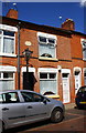
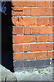
#54 Worthington Street
There is an OS benchmark Image in the bricks between the two white doors
Image: © Roger Templeman
Taken: 5 May 2017
0.02 miles
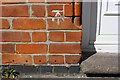
2
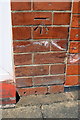
Benchmark on #54 Worthington Street
Ordnance Survey cut mark benchmark described on the Bench Mark Database at http://www.bench-marks.org.uk/bm84467
Image: © Roger Templeman
Taken: 5 May 2017
0.02 miles
3
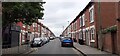
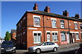
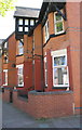
Twycross Street
Terraced houses, typical of this inner city area.
Image: © Peter Mackenzie
Taken: 24 Jun 2021
0.03 miles
4
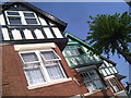
May comes to Mere Road
An oft unexplored part of Leicester, these colourful gables are typical along Mere Road, and the trees at this time of year make it a very pleasant place to be in Leicester.
Image: © Tim Hallam
Taken: 11 May 2006
0.04 miles
5
Benchmark on #107 Earl Howe Street
Ordnance Survey cut mark benchmark described on the Bench Mark Database at http://www.bench-marks.org.uk/bm84481
Image: © Roger Templeman
Taken: 5 May 2017
0.05 miles
6
Houses at Kings Newton Street / Earl Howe Street junction
There is an Ordnance Survey benchmark Image on the corner of the left hand house under the Kings Newton Street sign
Image: © Roger Templeman
Taken: 5 May 2017
0.05 miles
7
Benchmark on #40 Donnington Street
Ordnance Survey cut mark benchmark described on the Bench Mark Database at http://www.bench-marks.org.uk/bm84468
Image: © Roger Templeman
Taken: 5 May 2017
0.06 miles
8
Houses on Donnington Street
There is an OS benchmark Image picked out in white left of the white door in the middle of the image
Image: © Roger Templeman
Taken: 5 May 2017
0.06 miles
9
#207 Mere Road at Twycross Street junction
Image: © Roger Templeman
Taken: 5 May 2017
0.06 miles
10
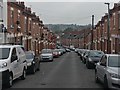
Fairfield Street in Spinney Hills, Leicester
Spinney Hills is an inner city area of Leicester.
Image: © Mat Fascione
Taken: 16 Sep 2019
0.08 miles