IMAGES TAKEN NEAR TO
Lubbesthorpe Bridle Road, LEICESTER, LE19 4LJ
Introduction
This page details the photographs taken nearby to Lubbesthorpe Bridle Road, LE19 4LJ by members of the Geograph project.
The Geograph project started in 2005 with the aim of publishing, organising and preserving representative images for every square kilometre of Great Britain, Ireland and the Isle of Man.

There are currently over 7.5m images from over14,400 individuals and you can help contribute to the project by visiting https://www.geograph.org.uk
Image Map
Images are licensed for reuse under creativecommons.org/licenses/by-sa/2.0
Notes
- Clicking on the map will re-center to the selected point.
- The higher the marker number, the further away the image location is from the centre of the postcode.
Image Listing (143 Images Found)
Images are licensed for reuse under creativecommons.org/licenses/by-sa/2.0
Image
Details
Distance
1
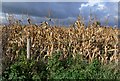
Dried corn field along Lubbesthorpe Bridle Road
Image: © Mat Fascione
Taken: 16 Oct 2010
0.01 miles
2
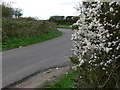
Blackberry blossom along Lubbesthorpe Bridle Road
Image: © Mat Fascione
Taken: 15 Apr 2012
0.02 miles
3
Watergate Lane
A burned out car by the roadside on Wathergate Lane
Image: © Richard Croft
Taken: 19 Jan 2011
0.03 miles
4
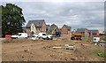
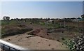
Houses under construction at New Lubbesthorpe
Image: © Mat Fascione
Taken: 20 Jun 2019
0.03 miles
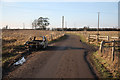
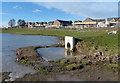
7
Former Lubbesthorpe Bridle Road
It is unclear whether this portion of the Lubbesthorpe Bridle Road will be restored.
Image: © Andrew Tatlow
Taken: 7 May 2018
0.04 miles
10
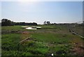
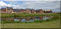
Frozen flood basin at New Lubbesthorpe
This is the site of the New Lubbesthorpe housing development, 4,250 homes will be built on a site that lies to the west of the M1, east of Beggar’s Lane, south of Leicester Forest East and north and south of the M69.
This is one of the first areas to be developed known as Hereswode.
Image: © Mat Fascione
Taken: 3 Feb 2019
0.04 miles