IMAGES TAKEN NEAR TO
West Walk, LEICESTER, LE1 7NP
Introduction
This page details the photographs taken nearby to West Walk, LE1 7NP by members of the Geograph project.
The Geograph project started in 2005 with the aim of publishing, organising and preserving representative images for every square kilometre of Great Britain, Ireland and the Isle of Man.

There are currently over 7.5m images from over14,400 individuals and you can help contribute to the project by visiting https://www.geograph.org.uk
Image Map
Images are licensed for reuse under creativecommons.org/licenses/by-sa/2.0
Notes
- Clicking on the map will re-center to the selected point.
- The higher the marker number, the further away the image location is from the centre of the postcode.
Image Listing (388 Images Found)
Images are licensed for reuse under creativecommons.org/licenses/by-sa/2.0
Image
Details
Distance
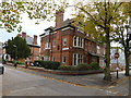
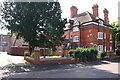
1
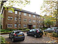
Pair of apartment houses
Two identical blocks of apartment houses from the 1930s in West Walk
Image: © Bob Harvey
Taken: 20 Oct 2014
0.01 miles
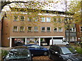
2
Pair of apartment houses
The other block adjacent to the ones in Image]
Image: © Bob Harvey
Taken: 20 Oct 2014
0.01 miles
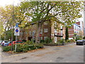
3
Infill development
Typical of the building work of the 60s to early 80s, before modernism went out of fashion, this apartment block with through access to parking was built on a bomb site.
Image: © Bob Harvey
Taken: 20 Oct 2014
0.02 miles
4
The Oval next to New Walk in Leicester
Image: © Mat Fascione
Taken: 21 Feb 2017
0.02 miles
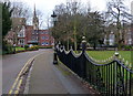
5

New Walk in Leicester
On the left is a small open space called The Oval.
Image: © Mat Fascione
Taken: 21 Feb 2017
0.03 miles
7
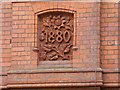
Datestone
Elaborate terracotta datestone on the house in Image]
Image: © Bob Harvey
Taken: 20 Oct 2014
0.03 miles
8
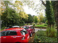
Back of the Oval
The pleasant spaces left around New Walk really bring life into this city area
Image: © Bob Harvey
Taken: 20 Oct 2014
0.03 miles
9
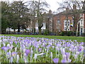
Spring flowers in The Oval
The Oval is a small open space next to New Walk in Leicester.
Image: © Mat Fascione
Taken: 21 Feb 2017
0.03 miles
10
No. 101 Princess Road East
Ordnance Survey documents indicate that in 1965 a benchmark levelled at 80.988m above Newlyn Datum was verified on the corner of the wall at its left hand end. There is no sign of a benchmark there now, so perhaps the corner pier has been rebuilt
Image: © phil Richards
Taken: 9 Sep 2017
0.03 miles