IMAGES TAKEN NEAR TO
Elmcroft Road, LUTTERWORTH, LE17 6HX
Introduction
This page details the photographs taken nearby to Elmcroft Road, LE17 6HX by members of the Geograph project.
The Geograph project started in 2005 with the aim of publishing, organising and preserving representative images for every square kilometre of Great Britain, Ireland and the Isle of Man.

There are currently over 7.5m images from over14,400 individuals and you can help contribute to the project by visiting https://www.geograph.org.uk
Image Map
Images are licensed for reuse under creativecommons.org/licenses/by-sa/2.0
Notes
- Clicking on the map will re-center to the selected point.
- The higher the marker number, the further away the image location is from the centre of the postcode.
Image Listing (54 Images Found)
Images are licensed for reuse under creativecommons.org/licenses/by-sa/2.0
Image
Details
Distance
1
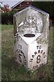
Old Milepost by the A4304, Station Road, North Kilworth
Cast iron post by the A4304 (was A427), in parish of NORTH KILWORTH (HARBOROUGH District), Station Road; by "Coltone", East of village centre, on the verge, on South side of road. Illston iron casting, erected by the Market Harborough & Coventry turnpike trust in the 19th century.
Inscription reads:-
: TO / LUTTERWORTH / 5 / MILES : : {Royal Arms of Queen Victoria} : : TO / HARBORO / 8 / MILES :
Maker:-
: JOSEPH / ILLSTON / VICTORIA FOUNDRY / LEICESTER :
Grade II Listed. List Entry Number: 1294817
https://historicengland.org.uk/listing/the-list/list-entry/1294817
Milestone Society National ID: LE_LUMH05.
Image: © J Higgins
Taken: 1 Dec 2004
0.03 miles
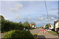
3
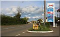
Howkins' Garage, North Kilworth
Due to bad experiences you have to pay for petrol in advance and a machine allows it to fill the exact amount and stop on its own. I also recommend the toilets if anyone's in the area.
Image: © David Howard
Taken: 16 May 2021
0.10 miles
4
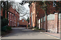
Cranmer Lane, North Kilworth
Cranmer Lane is a quiet road leading off The Green in the centre of North Kilworth down to The Bogs - a former gravel pit now a wetland nature reserve. Until the turnpike road was built in 1755 (now the A4304) it was the road out of the village to Market Harborough.
Image: © Stephen McKay
Taken: 31 Mar 2021
0.10 miles
5

Spring Cottage, North Kilworth
This delightful thatched cottage on Cranmer Lane looks idyllic nowadays but in the years after 1890 it would have been on the route to the village rubbish tip in the area now known as The Bogs. It was grade II listed in 1992 and is of 17th century origin, or possibly earlier, with later alterations. A snippet extracted from the Market Harborough Advertiser of December 1938, and reprinted in the North Kilworth News in 2018, tells of a Mr James F. Oxley who lived in this house at the time and retired after working as a signalman at Welford & North Kilworth station for 40 years
Image: © Stephen McKay
Taken: 31 Mar 2021
0.10 miles
6
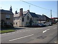
North Kilworth
The Swan Public House, one of two Pubs close together.
Image: © Ian Rob
Taken: 21 Sep 2006
0.10 miles
7
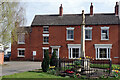
The Green, North Kilworth
The houses in this view are on the east side of The Green; the village war memorial, which was unveiled in 1920, is in the foreground.
Image: © Stephen McKay
Taken: 31 Mar 2021
0.10 miles
9
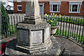
North Kilworth War Memorial
This is a close up of some of the names at the foot of North Kilworth's war memorial. It is worth noting that the list includes men who served and returned as well as those who lost their lives. See Image for further details.
Image: © Stephen McKay
Taken: 31 Mar 2021
0.11 miles
10
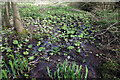
The Bogs
The Bogs is a 0.49 hectare of wetland fed by springs immediately to the north of North Kilworth Millennium Green. The area was once used for gravel extraction and, from 1890, as the village rubbish dump. It has now been cleaned up and is home to a variety of plant species including butterbur, which can be seen flowering in this springtime view. After flowering, butterbur (petasites hybridus), also known as wild rhubarb, grows very large leaves, up to 1m in diameter, which used to be used to preserve butter.
Image: © Stephen McKay
Taken: 31 Mar 2021
0.11 miles