IMAGES TAKEN NEAR TO
New Walk, LEICESTER, LE1 6TF
Introduction
This page details the photographs taken nearby to New Walk, LE1 6TF by members of the Geograph project.
The Geograph project started in 2005 with the aim of publishing, organising and preserving representative images for every square kilometre of Great Britain, Ireland and the Isle of Man.

There are currently over 7.5m images from over14,400 individuals and you can help contribute to the project by visiting https://www.geograph.org.uk
Image Map
Images are licensed for reuse under creativecommons.org/licenses/by-sa/2.0
Notes
- Clicking on the map will re-center to the selected point.
- The higher the marker number, the further away the image location is from the centre of the postcode.
Image Listing (643 Images Found)
Images are licensed for reuse under creativecommons.org/licenses/by-sa/2.0
Image
Details
Distance


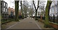
3

New Walk in Leicester
A pedestrianised area dating back to 1785. It runs between Granville Road at Victoria Park, to Welford Place in Leicester city centre.
Image: © Mat Fascione
Taken: 11 May 2019
0.03 miles
4
New Walk, Leicester LE1
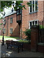
An entrance into Holy Cross Priory off New Walk, a footpath linking the city centre with Victoria Park on the east side of the city. It was a certain Benedict Caestryck (b.1762) from near Poperinghe, Belgium who founded a mission church in Leicester in 1819. The priory however, was not established until 1882. The Dominican friars (a.k.a. the Black Friars) are responsible for the chaplaincies to both of the city’s universities and also to the Royal Infirmary.
Image: © David Hallam-Jones
Taken: 24 Aug 2014
0.03 miles
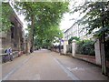
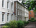
5

27-37 New Walk, Leicester
Late-Georgian or early-Victorian stuccoed terrace - Pevsner says before 1844 - rebuilt as a frontage to a new building. Grade II listed.
Image: © Stephen Richards
Taken: 24 Aug 2011
0.03 miles
6

New Walk in Leicester
A pedestrianised area dating back to 1785. It runs between Granville Road at Victoria Park, to Welford Place in Leicester city centre.
This photo was taken at 15:15 on a Monday afternoon, normally this area would be busy with pedestrians. It is deserted due to the Coronavirus (COVID-19) Pandemic.
Image: © Mat Fascione
Taken: 30 Mar 2020
0.03 miles
7
New Walk in Leicester
A pedestrianised area dating back to 1785. It runs between Granville Road at Victoria Park, to Welford Place in Leicester city centre.
This photo was taken at 15:15 on a Monday afternoon, normally this area would be busy with pedestrians. It is deserted due to the Coronavirus (COVID-19) Pandemic.
Image: © Mat Fascione
Taken: 30 Mar 2020
0.03 miles
8
New Walk, Leicester
Looking SE from near the Holy Cross Priory
Image: © Paul Gillett
Taken: 27 Jun 2014
0.03 miles
9
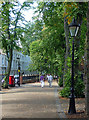
New Walk, Leicester
A pleasant pedestrian route lined with trees and, by and large, buildings easy on the eye. As such a promenade it is, Pevsner remarks, "unique in England ... for it is right in the middle of town and yet has resisted the intrustion of wheeled traffic." It was begun by the Corporation in 1785.
Image: © Stephen Richards
Taken: 24 Aug 2011
0.03 miles
10
Leicester - offices on south side of New Walk
Image: © Dave Bevis
Taken: 1 Jul 2012
0.04 miles