IMAGES TAKEN NEAR TO
King Street, LEICESTER, LE1 6RP
Introduction
This page details the photographs taken nearby to King Street, LE1 6RP by members of the Geograph project.
The Geograph project started in 2005 with the aim of publishing, organising and preserving representative images for every square kilometre of Great Britain, Ireland and the Isle of Man.

There are currently over 7.5m images from over14,400 individuals and you can help contribute to the project by visiting https://www.geograph.org.uk
Image Map
Images are licensed for reuse under creativecommons.org/licenses/by-sa/2.0
Notes
- Clicking on the map will re-center to the selected point.
- The higher the marker number, the further away the image location is from the centre of the postcode.
Image Listing (463 Images Found)
Images are licensed for reuse under creativecommons.org/licenses/by-sa/2.0
Image
Details
Distance
2
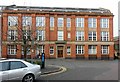
Former Driver's hosiery factory, King Street
Early 20th century, a typical example of one Leicester's principal industries. Now converted to office use. See also http://www.geograph.org.uk/photo/6041737
Image: © Alan Murray-Rust
Taken: 26 Jan 2019
0.02 miles
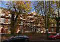
3
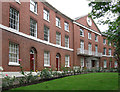
The Crescent on King Street, Leicester
Built in 1826 by James Rawson, The Crescent is one of Leicester's best surviving examples of Georgian architecture. The houses are now converted into offices.
Image: © Mat Fascione
Taken: 2 Apr 2017
0.02 miles
5
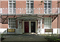
Detail of the Crescent, King Street, Leicester
Pretty cast-iron porch and balcony at the middle of this terrace: Image
Image: © Stephen Richards
Taken: 24 Aug 2011
0.03 miles
6
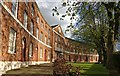
The Crescent, King Street
At the time of my visit this fine building was significantly concealed behind scaffolding.
Built in 1826 as a group of 14 houses, it switched gradually from residential to office use after the First World War. In the 1960s it was scheduled for demolition to make way for the City's inner ring road, but this project was not completed as originally planned. The interiors were gutted and rebuilt for office use in the 1970s, but despite this The Crescent has Grade II* Listed status. The listing details give the building date as c.1810, but the 1826 date is clearly documented elsewhere. It falls within the New Walk Conservation area.
Image: © Alan Murray-Rust
Taken: 9 Nov 2013
0.03 miles
7
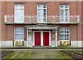
The Crescent, King Street, Leicester
The central block with entrance porch and balconies. Regency style, c.1810. Listed Grade II*.
See http://www.geograph.org.uk/photo/6041724 for location.
Image: © Alan Murray-Rust
Taken: 26 Jan 2019
0.03 miles
8
The Crescent, King Street, Leicester
Detail of the cast-iron work of the central porch.
See http://www.geograph.org.uk/photo/6041731 for location.
Image: © Alan Murray-Rust
Taken: 26 Jan 2019
0.03 miles
9
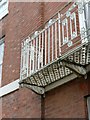
The Crescent, King Street, Leicester
Detail of the cast-iron work of the central balcony. See http://www.geograph.org.uk/photo/6041731 for location.
Image: © Alan Murray-Rust
Taken: 26 Jan 2019
0.03 miles
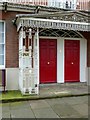
10

Herbert L. Driver Ltd, Hosiery Manufacturers
Doorway to former hosiery factory, see http://www.geograph.org.uk/photo/6041740 for location.
Image: © Alan Murray-Rust
Taken: 26 Jan 2019
0.03 miles