1
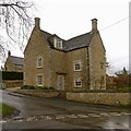
Cornerstone House, Chapel Lane, Barrowden
Late 17th century house, squared coursed limestone with Collyweston stone slate roof, Listed Grade II. The tablet set in the garden wall records the restoration of the house in 1979 and infers a 15th century date but the style is more in keeping with the 17th century dating of the Listing description.
Image: © Alan Murray-Rust
Taken: 4 Apr 2016
0.02 miles
2
Village Green, Barrowden
Previous names for the village (from http://www.british-history.ac.uk/vch/rutland/vol2/pp170-175):
Berchedon (11th cent.); Bergeduna, Bergendona, Bereweydun 12th cent.); Berewedone, Berwedon, Berudon (13th cent.); Beroughden, Bergdon, Berughdon (14th cent.); Barowdon, Barowghdon (15th cent.); Baroughden, Barrowdon (xvi cent.).
Image: © Tim Heaton
Taken: 25 Apr 2018
0.02 miles
3
Welland View Farmhouse
18th century farmhouse, coursed stone rubble with Collyweston stone slate roof, Listed Grade II.
Image: © Alan Murray-Rust
Taken: 11 Apr 2016
0.02 miles
4
Bench mark, Swan Cottage, Barrowden
See http://www.geograph.org.uk/photo/4899708 for location.
Image: © Alan Murray-Rust
Taken: 4 Apr 2016
0.03 miles
5
Chapel Lane, Barrowden
The first house, Cornerstone House, 2 Chapel Lane, is Grade II Listed late 17th century. In the distance also Grade II Listed is 8 Chapel Lane dated 1799 and formerly known as Smithy House.
Image: © Jo and Steve Turner
Taken: 28 Aug 2017
0.03 miles
6
Swan Cottage, Main Street, Barrowden
Stone built with Welsh slate roof, probably early to mid 19th century. There is a bench mark http://www.geograph.org.uk/photo/4899707 on the far corner of the house next to the garden wall.
Image: © Alan Murray-Rust
Taken: 4 Apr 2016
0.03 miles
7
8, Chapel Lane, Barrowden
Cottage with unusual Mansard roof, dated 1799 in the gable end; coursed stone rubble with Collyweston stone slate roof, Listed Grade II for group value.
Image: © Alan Murray-Rust
Taken: 11 Apr 2016
0.04 miles
8
Barrowden, Rutland - Village green
Image: © Colin Park
Taken: 12 Oct 2016
0.04 miles
9
Former smithy building, Barrowden
Sitting in the middle of the green. The current use is unclear – there are only the two windows visible here, but the modern flue suggests some modernisation.
Image: © Alan Murray-Rust
Taken: 4 Apr 2016
0.04 miles
10
Orchard at Barrowden
Walking along Main Street in Barrowden, this small orchard is next to the road.
Image: © Marathon
Taken: 24 May 2011
0.05 miles


