IMAGES TAKEN NEAR TO
Chapel Lane, OAKHAM, LE15 8EB
Introduction
This page details the photographs taken nearby to Chapel Lane, LE15 8EB by members of the Geograph project.
The Geograph project started in 2005 with the aim of publishing, organising and preserving representative images for every square kilometre of Great Britain, Ireland and the Isle of Man.

There are currently over 7.5m images from over14,400 individuals and you can help contribute to the project by visiting https://www.geograph.org.uk
Image Map (Loading...)


Getting Data...Please wait
Leaflet Map data © OpenStreetMap
Images are licensed for reuse under creativecommons.org/licenses/by-sa/2.0
Notes
- Clicking on the map will re-center to the selected point.
- The higher the marker number, the further away the image location is from the centre of the postcode.
Image Listing (122 Images Found)
Images are licensed for reuse under creativecommons.org/licenses/by-sa/2.0
Image
Details
Distance
1
Orchard House, Barrowden
Cottage dating from c.1700, coursed stone rubble with Collyweston stone slate roof, Listed Grade II. At this end a 21st century extension in matching stone construction, but with modern slate roof.
Image: © Alan Murray-Rust
Taken: 11 Apr 2016
0.02 miles
2
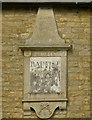
Datestone, former Baptist Chapel, Barrowden
See http://www.geograph.org.uk/photo/4908231 for location.
Image: © Alan Murray-Rust
Taken: 11 Apr 2016
0.03 miles
3
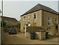
Former Baptist Chapel, Barrowden
Dated 1819 http://www.geograph.org.uk/photo/4908230, coursed stone rubble with ashlar dressings and Welsh slate hipped roof. Converted early 21st century to residential use, Listed Grade II.
Image: © Alan Murray-Rust
Taken: 11 Apr 2016
0.03 miles
4
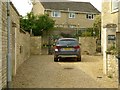
Forecourt to former Baptist Chapel, Barrowden
The cast iron gates visible beyond the car are Listed Grade II for group value. They were originally sited between the two stone piers in the foreground, but when the chapel was converted to a house, the gates were clearly too narrow to allow a car through, so they have been moved.
Image: © Alan Murray-Rust
Taken: 11 Apr 2016
0.03 miles
5
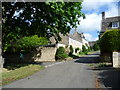
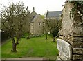
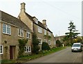
Chapel Lane, Barrowden
Rutland is full of attractive villages and Barrowden certainly does not let the county down. This view is from the east end of the village green looking up Chapel Lane.
Image: © Marathon
Taken: 24 May 2011
0.03 miles
6
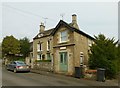
20 Chapel Lane, Barrowden
The main house is dated 1823 http://www.geograph.org.uk/photo/4908228, the nearer wing being a late 19th century addition; coursed stone rubble with ashlar dressings and Collyweston stone slate roof, Listed Grade II.
Image: © Alan Murray-Rust
Taken: 11 Apr 2016
0.03 miles
7
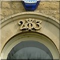
Datestone, 20 Chapel Lane, Barrowden
The keystone of the central first floor window. See http://www.geograph.org.uk/photo/4908226 for location. (The date is 1823)
Image: © Alan Murray-Rust
Taken: 11 Apr 2016
0.03 miles
8
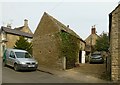
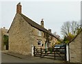
Stable building at 12 Chapel Lane, Barrowden
Built c.1800, coursed stone rubble with Collyweston stone slate roof, Listed Grade II for group value. The house at the back is also Listed Grade II, but not readily photographable.
Image: © Alan Murray-Rust
Taken: 11 Apr 2016
0.04 miles
9
Amberleigh House, Barrowden
18th century house, coursed stone rubble with Collyweston stone slate roof, Listed Grade II.
Image: © Alan Murray-Rust
Taken: 11 Apr 2016
0.05 miles
10
10 Chapel Lane, Barrowden
18th century cottage, coursed stone rubble with Collyweston stone slate roof, with later extension partly in brick and with Welsh slate roof. Listed Grade II for group value.
Image: © Alan Murray-Rust
Taken: 11 Apr 2016
0.05 miles