IMAGES TAKEN NEAR TO
Main Road, OAKHAM, LE15 8BW
Introduction
This page details the photographs taken nearby to Main Road, LE15 8BW by members of the Geograph project.
The Geograph project started in 2005 with the aim of publishing, organising and preserving representative images for every square kilometre of Great Britain, Ireland and the Isle of Man.

There are currently over 7.5m images from over14,400 individuals and you can help contribute to the project by visiting https://www.geograph.org.uk
Image Map
Images are licensed for reuse under creativecommons.org/licenses/by-sa/2.0
Notes
- Clicking on the map will re-center to the selected point.
- The higher the marker number, the further away the image location is from the centre of the postcode.
Image Listing (60 Images Found)
Images are licensed for reuse under creativecommons.org/licenses/by-sa/2.0
Image
Details
Distance
1
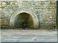
Parish conduit
Created in 1858 as a common supply of water for the village. It was fed from the White Well spring that gave its name to the village. Listed Grade II with the barn it is built into.
Image: © Alan Murray-Rust
Taken: 3 Feb 2016
0.02 miles
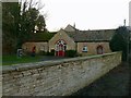
2
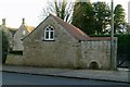
Former coachhouse and parish conduit
See http://www.geograph.org.uk/photo/4819349 and http://www.geograph.org.uk/photo/4819341 for more details.
Image: © Alan Murray-Rust
Taken: 3 Feb 2016
0.03 miles
3
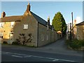
Home Farmhouse
Probably 18th century, extended 19th. Listed Grade II. The lane to the right forms part of the Viking Way, towards Exton.
Image: © Alan Murray-Rust
Taken: 3 Feb 2016
0.03 miles
4
The coachhouse, Whitwell Rectory
Taken in 1965 when the photographer lived at the Rectory.
Submitted for comparison with http://www.geograph.org.uk/photo/4819349
Image: © Sam Bartlett
Taken: Unknown
0.03 miles
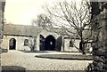
5
Coachhouse at The Rectory
Early 19th century, the use of brick dressings for the openings is unusual. Gothick style arches and windows, Listed Grade II. (Described in the Listing as a barn rather than a coachhouse). See also http://www.geograph.org.uk/photo/4819337 and http://www.geograph.org.uk/photo/5362271
Image: © Alan Murray-Rust
Taken: 3 Feb 2016
0.03 miles
6

The Noel at Whitwell
Named after the Noel family of Exton, former Lords of the Manor. The Viking Way, having left Oakham and the shore of Rutland Water, heads north up this driveway on a 145 mile route to the Humber Bridge
Image: © Tim Heaton
Taken: 27 May 2016
0.03 miles
7
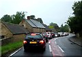
6am traffic jam at Whitwell
There was some sort of event on at Rutland water and some dire traffic control by the 20 or so policemen milling around in the middle of the road about half a mile ahead. The A606 had long traffic jams in both directions. I just wanted to get the last 15 miles home and to bed!
Image: © Andrew Tatlow
Taken: 22 Jun 2013
0.03 miles
8
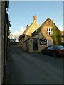
The Noel, Whitwell
Formerly the Noel Arms, but rebranded as a more upmarket restaurant.
The part of the building shown here dates back to probably the 17th century, coursed stone rubble with thatched roof. Listed Grade II.
Image: © Alan Murray-Rust
Taken: 3 Feb 2016
0.04 miles
9
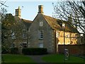
The Rectory, Whitwell
Created around an earlier 16th century house, the visible work is 18th and 19th century. The nearer range is the earlier part. coursed stone rubble with stone tile roof. Listed Grade II.
Image: © Alan Murray-Rust
Taken: 3 Feb 2016
0.04 miles
10
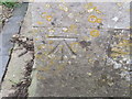
Ordnance Survey Cut Mark
This can be found on the wall of St Michael's and All Angels Church.
For more detail see : http://www.bench-marks.org.uk/bm41251
Image: © Peter Wood
Taken: 28 Nov 2012
0.05 miles