IMAGES TAKEN NEAR TO
Walker Close, OAKHAM, LE15 7FG
Introduction
This page details the photographs taken nearby to Walker Close, LE15 7FG by members of the Geograph project.
The Geograph project started in 2005 with the aim of publishing, organising and preserving representative images for every square kilometre of Great Britain, Ireland and the Isle of Man.

There are currently over 7.5m images from over14,400 individuals and you can help contribute to the project by visiting https://www.geograph.org.uk
Image Map (Loading...)


Getting Data...Please wait
Leaflet Map data © OpenStreetMap
Images are licensed for reuse under creativecommons.org/licenses/by-sa/2.0
Notes
- Clicking on the map will re-center to the selected point.
- The higher the marker number, the further away the image location is from the centre of the postcode.
Image Listing (46 Images Found)
Images are licensed for reuse under creativecommons.org/licenses/by-sa/2.0
Image
Details
Distance
1
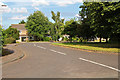
New housing, Market Overton
Looking down The Limes towards The Finches, part of a small 20th Century housing estate to the east of the village.
Image: © Kate Jewell
Taken: 9 Aug 2015
0.09 miles
2
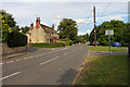
Main Street, Market Overton
Looking away from the village centre. Bowling Green Lane is on the left.
Image: © Kate Jewell
Taken: 9 Aug 2015
0.10 miles
3
A little green at Market Overton
At the junction of Main Street with Woodhead Close.
Image: © Alan Murray-Rust
Taken: 15 Jan 2016
0.10 miles
4
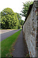
Bowling Green Lane, Market Overton
A substantial stone wall denotes the boundary between Stone House's garden and the village street.
Image: © Kate Jewell
Taken: 9 Aug 2015
0.11 miles
5
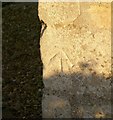
Bench mark, 48 Main Street, Market Overton
See http://www.geograph.org.uk/photo/4796267 for location.
Image: © Alan Murray-Rust
Taken: 15 Jan 2016
0.11 miles
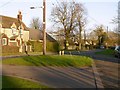
6
48 & 50 Main Street, Market Overton
A pair of probably late 19th century cottages. There is a bench mark http://www.geograph.org.uk/photo/4796266 on the left hand corner of the gable end.
Image: © Alan Murray-Rust
Taken: 15 Jan 2016
0.11 miles
7
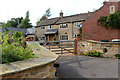
Off Bowling Green Lane
This is typical of housing in Market Overton: village houses and cottages set back from the road in clusters.
Image: © Kate Jewell
Taken: 9 Aug 2015
0.11 miles
8
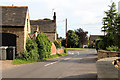
Junction at the end of Bowling Green Lane
Bowling Green Lane meets Main Street.
Image: © Kate Jewell
Taken: 9 Aug 2015
0.11 miles
9
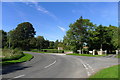
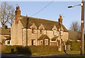
Entering Market Overton from the south
Ahead is the entrance to grounds of The Lodge Trust, a Christian charity providing support for adults with learning disabilities. The grounds also provide log cabin holidays and camping facilities.
Image: © Tim Heaton
Taken: 3 Oct 2016
0.12 miles
10
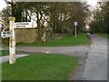
Fingerpost near The Lodge
Standard Rutland County Council concrete style. The lane beyond is now a no through road, but formerly connected to Stretton. It was cut when Cottesmore airfield was constructed.
Image: © Alan Murray-Rust
Taken: 15 Jan 2016
0.13 miles