IMAGES TAKEN NEAR TO
The Spinney, OAKHAM, LE15 7BP
Introduction
This page details the photographs taken nearby to The Spinney, LE15 7BP by members of the Geograph project.
The Geograph project started in 2005 with the aim of publishing, organising and preserving representative images for every square kilometre of Great Britain, Ireland and the Isle of Man.

There are currently over 7.5m images from over14,400 individuals and you can help contribute to the project by visiting https://www.geograph.org.uk
Image Map (Loading...)


Getting Data...Please wait
Leaflet Map data © OpenStreetMap
Images are licensed for reuse under creativecommons.org/licenses/by-sa/2.0
Notes
- Clicking on the map will re-center to the selected point.
- The higher the marker number, the further away the image location is from the centre of the postcode.
Image Listing (111 Images Found)
Images are licensed for reuse under creativecommons.org/licenses/by-sa/2.0
Image
Details
Distance
1

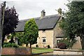
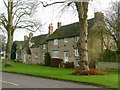
Holme Farmhouse, Main Street
18th century farmhouse in coursed limestone rubble, extended in brick in the early 20th century when the tiled roof was added. Listed Grade II.
Image: © Alan Murray-Rust
Taken: 19 Jan 2016
0.03 miles
2

Holme Farmhouse, 10 Main Street, Cottesmore
Grade II Listed 18th century house, extended in the 20th century. The listing claim that the extension is 20th century is questionable. The brickwork appears to be an inconsistent mixture of bonds and the windows suggest a pre-1840 date. At the rear of the extension is a lean-to that strangely has a ceiling beam dated as 16th century. The farm was originally part of the Exton Estate and leased with substantial land to tenant farmers. It seems to have started life in mid to late 18th century as a three room stone-built block with the rear wing connecting to the outbuildings added at an early stage. It ceased to be an active farm about 1985 and the barns and cowsheds were converted in the 1990s. The earliest reference to Holme Farm is a map of about 1730 that names William Blackley as the tenant. The map apparently shows a prior structure (origin of the beam?). Holme Farm is not named in the first 5 census returns (1841-1881). In 1913 it was described as Stone, thatch and slate roofed 10 roomed house, bath, dairy and wash house, very fair condition. This suggests the extension was extant by then. (It is also found as Home and Holm farm).
Image: © Jo and Steve Turner
Taken: 24 Aug 2023
0.03 miles
3
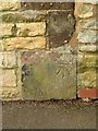
Bench mark, Fir Tree Barn
See http://www.geograph.org.uk/photo/4801026 for location.
Image: © Alan Murray-Rust
Taken: 19 Jan 2016
0.04 miles
4

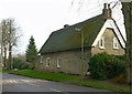
Fir Tree Farmhouse, Main Street
Farmhouse from around 1700 in coursed squared limestone with thatched roof. Listed Grade II, the listing includes the L-shaped wings to the left rear.
Image: © Alan Murray-Rust
Taken: 19 Jan 2016
0.04 miles
5
Fir Tree Farmhouse, 16 Main Street, Cottesmore
17th/18th century Grade II Listed farmhouse with single storey extension. Now a privately owned 4,190 sq ft 5 bedroom house, previously it was part of the Exton estate and a working farm. The original three rooms have beams dated to 1709 and one 1568-93 beam presumably re-used from another building, possibly on this plot. Records show that Lord Gainsborough was the original owner and in the 1730s John Hardy was one of the earliest tenants to rent the property.
Image: © Jo and Steve Turner
Taken: 24 Aug 2023
0.05 miles
6
5, Main Street ('The Thatch')
18th century cottage in coursed limestone rubble with thatched roof. Listed Grade II.
Image: © Alan Murray-Rust
Taken: 19 Jan 2016
0.05 miles
7

The Thatch, 5 Main Street, Cottesmore
Grade II Listed 18th century cottage. This is a grade II listed 18th century thatched cottage. Mr H D Smith, headmaster of the Central School lived here in the 1930s. He also lived at Ivy Cottage next door.
Image: © Jo and Steve Turner
Taken: 24 Aug 2023
0.05 miles
8
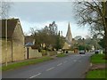
Main Street, Cottesmore
Looking east into the centre of the village. There is a bench mark http://www.geograph.org.uk/photo/4801021 at the far corner of the gable to the left of the picture.
Image: © Alan Murray-Rust
Taken: 19 Jan 2016
0.05 miles
9
The Limes and Wren Cottage, Main Street
Two 18th century cottages in coursed limestone rubble, the nearer (the Limes) with modern tile roof, the further (Wren Cottage) dated 1775 with Collyweston stone slate roof. Listed Grade II.
Image: © Alan Murray-Rust
Taken: 19 Jan 2016
0.06 miles
10
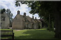
Cottages under the trees
A grade II building of 1775 - see https://historicengland.org.uk/listing/the-list/list-entry/1177099
Image: © Bob Harvey
Taken: 16 Jul 2021
0.06 miles