IMAGES TAKEN NEAR TO
Manor Court, MELTON MOWBRAY, LE14 4TA
Introduction
This page details the photographs taken nearby to Manor Court, LE14 4TA by members of the Geograph project.
The Geograph project started in 2005 with the aim of publishing, organising and preserving representative images for every square kilometre of Great Britain, Ireland and the Isle of Man.

There are currently over 7.5m images from over14,400 individuals and you can help contribute to the project by visiting https://www.geograph.org.uk
Image Map
Images are licensed for reuse under creativecommons.org/licenses/by-sa/2.0
Notes
- Clicking on the map will re-center to the selected point.
- The higher the marker number, the further away the image location is from the centre of the postcode.
Image Listing (84 Images Found)
Images are licensed for reuse under creativecommons.org/licenses/by-sa/2.0
Image
Details
Distance
1
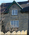
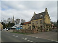
Detail of cottage on Melton Road, Waltham on the Wolds
This cottage, one of four semi-detached cottages on Melton Road, still retains its original windows. See Image
Image: © Kate Jewell
Taken: 17 Feb 2008
0.04 miles
2
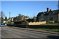
Cottages on Melton Road
These two sets of semi-detached cottages are constructed of limestone. All four have undergone extensive expansion over the years but still present a traditional façade to the road. Unfortunately only one retains the original lozenge design windows, see Image
Image: © Kate Jewell
Taken: 17 Feb 2008
0.04 miles
3
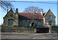
Waltham on the Wolds primary school
Built in 1844 from local limestone. The three large original classrooms in the old building house the older children. Across the playground at the rear of the building are three mobile classrooms which house the younger pupils. The school overlooks the Wolds countryside at the rear and has a large playing field and nature conservation area.
Image: © Kate Jewell
Taken: 17 Feb 2008
0.05 miles
4
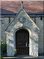
The school porch
This is the main visitor entrance to the school, the children access the buildings from the playground round the back. Note the coat of arms above the door which commemorates the erection of this building in 1844. It was built to replaced the old school which was founded by George Noble in 1776.
Image: © Kate Jewell
Taken: 17 Feb 2008
0.06 miles
5

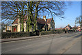
Melton Road, Waltham on the Wolds
The busy A607 to Grantham cuts through Waltham. There have been recent traffic calming measures made including pedestrian islands and a reduced width carriageway on the approach to the village. There is also a 20 miles per hour speed limit outside the school. Unfortunately none of these measures seem to have much effect on drivers.
Photograph taken looking north from the corner of Moor Leys Lane.
Image: © Kate Jewell
Taken: 17 Feb 2008
0.06 miles
6
Waltham on the Wolds primary school
On the west of the A607, this popular village school serves a wide rural area including the villages of Stonesby, Eaton, Branston and Eastwell
Image: © Kate Jewell
Taken: 17 Feb 2008
0.06 miles
7
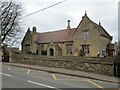
Waltham on the Wolds Church of England Primary School
Dates from 1844 https://historicengland.org.uk/listing/the-list/list-entry/1074973
Image: © Jonathan Thacker
Taken: 2 Apr 2021
0.07 miles
8
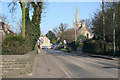
Melton Road, Waltham on the Wolds
The busy A607 passes through this popular limestone village making for an easy commute into Melton Mowbray to the south and Grantham to the north. The spire of St Mary Magdalene Church in Image can be seen to the left.
Image: © Kate Jewell
Taken: 17 Feb 2008
0.08 miles
9
Gale House, Waltham on the Wolds
Eighteenth century house https://historicengland.org.uk/listing/the-list/list-entry/1188914
Image: © Jonathan Thacker
Taken: 2 Apr 2021
0.09 miles
10
Entering Waltham on the Wolds
Ona footpath from Chadwell.
Image: © Jonathan Thacker
Taken: 2 Apr 2021
0.11 miles