IMAGES TAKEN NEAR TO
St. James Street, LEICESTER, LE1 3SU
Introduction
This page details the photographs taken nearby to St. James Street, LE1 3SU by members of the Geograph project.
The Geograph project started in 2005 with the aim of publishing, organising and preserving representative images for every square kilometre of Great Britain, Ireland and the Isle of Man.

There are currently over 7.5m images from over14,400 individuals and you can help contribute to the project by visiting https://www.geograph.org.uk
Image Map
Images are licensed for reuse under creativecommons.org/licenses/by-sa/2.0
Notes
- Clicking on the map will re-center to the selected point.
- The higher the marker number, the further away the image location is from the centre of the postcode.
Image Listing (247 Images Found)
Images are licensed for reuse under creativecommons.org/licenses/by-sa/2.0
Image
Details
Distance
1
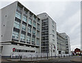
Wharf Street South in Leicester
The large building is The Exchange apartment block.
Image: © Mat Fascione
Taken: 21 Feb 2017
0.02 miles
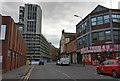
2
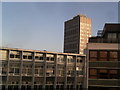
Offices and Cardinal Tower from Lee Circle
Lee Circle does afford some fine views across Leicester.
Image: © Tim Hallam
Taken: 13 Oct 2006
0.02 miles
3
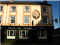
Humberstone Gate, Leicester
A view of the former Three Cranes Hotel now renamed The Cork and Bottle. This pub stands at the corner of Humberstone Gate & Wharf Street South.
Image: © Bobby Clegg
Taken: 16 Oct 2008
0.02 miles
4
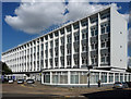
Former telephone exchange, Wharf Street, Leicester
A GPO architects' job, 1958-60, and not a bad one at that. Long and low (twenty-seven bays by five storeys), with distinctive fenestration and rounded ground-floor projections at each end which follow the curve of the road in front.
Unusually for such a building it has been converted to flats.
Image: © Stephen Richards
Taken: 24 Aug 2011
0.02 miles
5
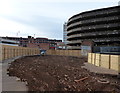
Demolition work at Lee Circle, Leicester
Image: © Mat Fascione
Taken: 25 Oct 2015
0.03 miles
6
Wharf Street South in Leicester city centre
Image: © Mat Fascione
Taken: 11 Sep 2020
0.04 miles
7
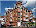
66a Humberstone Gate, Leicester
The website for this building, marketing its "affordable workspace for Leicester's creative businesses", states this Victorian building was originally a shoe and boot factory. It may never have had one, but the corner looks as if it has lost a turret or a dome.
Image: © Stephen Richards
Taken: 24 Aug 2011
0.04 miles
8
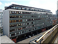
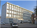
Metropolitan Building, Lee Street, Leicester
To me this has the look of a 1960s/1970s office block - it doesn't have the frills or jaunty angles of a new-build - but I can find no evidence for this and it is now flats, or in the modern parlance, apartments. For the last 10-20 years, most, if not all, British cities have pushed city-centre living, mostly targeted at young professional types, in an attempt to reverse their depopulation during non-working hours.
Image: © Stephen Richards
Taken: 24 Aug 2011
0.04 miles
9
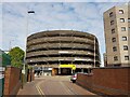
Lee Circle Car Park, Leicester
"An imposing early 1960s multi-storey car park built in an American-style, it was one of the first multi-storey car parks to be constructed in the UK and is also believed to have been the first automated car park in Europe. Built in 1961 to the designs of the nationally recognised architectural firm Fitzroy Robinson & Partners of London, the building when first constructed also had the first Tesco supermarket outside of London and shows the growing impact of the car in town planning during the mid-20th century." (Local Heritage Asset Register, Leicester city Council).
In a city with many post-war 'carbuncles', this is a prize.
Image: © Tim Heaton
Taken: 26 Apr 2022
0.05 miles
10
Former BT Telephone Exchange Lee Circle side
Currently being converted into "The Exchange" for "Exclusive City Living"; there will even be a "Fully Fitted Gymnasium" and a "Concierge Service"!
Image: © Andrew Tatlow
Taken: 4 Oct 2015
0.05 miles