IMAGES TAKEN NEAR TO
Clarence Street, LEICESTER, LE1 3RW
Introduction
This page details the photographs taken nearby to Clarence Street, LE1 3RW by members of the Geograph project.
The Geograph project started in 2005 with the aim of publishing, organising and preserving representative images for every square kilometre of Great Britain, Ireland and the Isle of Man.

There are currently over 7.5m images from over14,400 individuals and you can help contribute to the project by visiting https://www.geograph.org.uk
Image Map
Images are licensed for reuse under creativecommons.org/licenses/by-sa/2.0
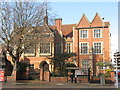
Notes
- Clicking on the map will re-center to the selected point.
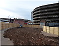
- The higher the marker number, the further away the image location is from the centre of the postcode.
Image Listing (298 Images Found)
Images are licensed for reuse under creativecommons.org/licenses/by-sa/2.0
Image
Details
Distance
1
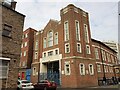
Former Salvation Army building, Kildare Street, Leicester
Offered for sale
Image: © Tim Heaton
Taken: 26 Apr 2022
0.02 miles
2
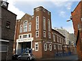
Leicester-The Salvation Army Central Corps
In Kildare Street.
Image: © Ian Rob
Taken: 22 Apr 2012
0.03 miles
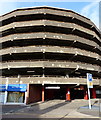
4
'Automagic'...Lee Circle Lives!
Rumour has it, and I'm regrettably, at this stage, unable to confirm, that this was the first Multi Storey Car Park in the UK. Can anyone shed any light? I do know that the interior is a spiral rather than ramps on to each floor and it was originally called 'Automagic' and affiliated to Tesco, that was on the ground floor part of the structure at that time, c 1965.
Image: © Tim Hallam
Taken: 4 Apr 2006
0.04 miles
5
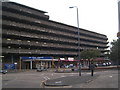
Automagic Again
Picture includes the notorious Lee Circle Trading Post on the ground floor, where Tesco once was.
Image: © Tim Hallam
Taken: 13 Oct 2006
0.04 miles
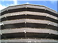
6
Atop Automagic
This picture shows the car ports at the top of Lee Circle. In the distance, the Tower that can be seen is the 'Lewis's' Tower on Humberstone Gate.
Image: © Tim Hallam
Taken: 13 Oct 2006
0.04 miles
7
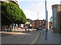
Lee Street
The Lee Circle NCP Car Park is to the left.
Image: © Andrew Tatlow
Taken: 31 Aug 2010
0.04 miles
8
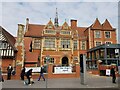
Clarence House, Humberstone Gate, Leicester
Listed Grade II, 1877.
Image: © Tim Heaton
Taken: 26 Apr 2022
0.04 miles
9
Leicester Clarence House
46 Humberstone Gate. Dated 1877, opened as Wyggeston Girls School. Changed to City Boys' School from 1928. Now Age Concern.
Image: © the bitterman
Taken: 18 Mar 2012
0.05 miles
10
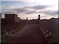
Demolition work at Lee Circle, Leicester
Image: © Mat Fascione
Taken: 25 Oct 2015
0.05 miles