IMAGES TAKEN NEAR TO
Firwood Road, MELTON MOWBRAY, LE13 1SA
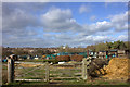
Introduction
This page details the photographs taken nearby to Firwood Road, LE13 1SA by members of the Geograph project.
The Geograph project started in 2005 with the aim of publishing, organising and preserving representative images for every square kilometre of Great Britain, Ireland and the Isle of Man.

There are currently over 7.5m images from over14,400 individuals and you can help contribute to the project by visiting https://www.geograph.org.uk
Image Map
Images are licensed for reuse under creativecommons.org/licenses/by-sa/2.0
Notes
- Clicking on the map will re-center to the selected point.
- The higher the marker number, the further away the image location is from the centre of the postcode.
Image Listing (38 Images Found)
Images are licensed for reuse under creativecommons.org/licenses/by-sa/2.0
Image
Details
Distance
1
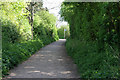
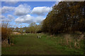
Path between Thorpe Park estate and Melton Country Park
Looking towards Doctor's Lane.
Image: © Kate Jewell
Taken: 25 Apr 2009
0.05 miles
2
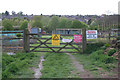
Doctor's Lane allotments
Fear ye who dare to enter here!
Image: © Kate Jewell
Taken: 25 Apr 2009
0.07 miles
3
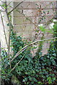
Benchmark on #26 Firwood Road
Ordnance Survey cut mark benchmark described on the Bench Mark Database at http://www.bench-marks.org.uk/bm42483
Image: © Roger Templeman
Taken: 10 Apr 2012
0.07 miles
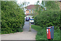
4
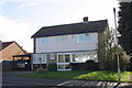
#26 Firwood Road
There is an OS benchmark Image on the right front corner of the house
Image: © Roger Templeman
Taken: 10 Apr 2012
0.07 miles
6
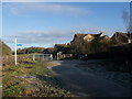
End of Doctor's Lane, Melton Mowbray
Cycle Route 64 passes through a small estate before leaving the north side of Melton Mowbray.
Image: © Tim Heaton
Taken: 9 Jan 2011
0.08 miles
7
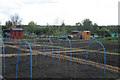
Doctor's Lane allotments
Immaculately kept allotment gardens at the end of Doctor's Lane.
Image: © Kate Jewell
Taken: 25 Apr 2009
0.09 miles
8
Access point to the Country Park
This path gives access to Melton Country Park from Ross Close on the Thorpe Park estate.
Image: © Kate Jewell
Taken: 25 Apr 2009
0.10 miles
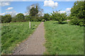
9
Path leading northwards from Doctors Lane
Image: © Robert Eva
Taken: 9 Feb 2019
0.12 miles
10
Jubilee Way Long Distance Footpath
The Jubilee Way is a 20 mile path from Burrough Hill Country Park starting in Image to Woolsthorpe in the Vale of Belvoir, where it meets the Viking Way at Image, which goes through the Melton Country Park.
Image: © Kate Jewell
Taken: 25 Apr 2009
0.15 miles