IMAGES TAKEN NEAR TO
Kashmir Road, LEICESTER, LE1 2NL
Introduction
This page details the photographs taken nearby to Kashmir Road, LE1 2NL by members of the Geograph project.
The Geograph project started in 2005 with the aim of publishing, organising and preserving representative images for every square kilometre of Great Britain, Ireland and the Isle of Man.

There are currently over 7.5m images from over14,400 individuals and you can help contribute to the project by visiting https://www.geograph.org.uk
Image Map
Images are licensed for reuse under creativecommons.org/licenses/by-sa/2.0
Notes
- Clicking on the map will re-center to the selected point.
- The higher the marker number, the further away the image location is from the centre of the postcode.
Image Listing (37 Images Found)
Images are licensed for reuse under creativecommons.org/licenses/by-sa/2.0
Image
Details
Distance
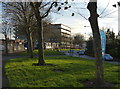
2
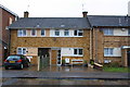
Housing on Kashmir Road in St Matthew's, Leicester
The St Matthew's estate is an inner city area of Leicester.
Image: © Mat Fascione
Taken: 18 Oct 2019
0.07 miles
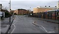
3
Arnold Street in St Matthew's, Leicester
The St Matthew's estate is an inner city area of Leicester.
Image: © Mat Fascione
Taken: 18 Oct 2019
0.08 miles
4
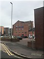
Entrance to Jewsons Landscaping Centre, #189 Humberstone Road
The roadside brick wall has been rebuilt in recent days
Image: © Roger Templeman
Taken: 5 May 2017
0.12 miles
5
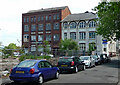
Former works, Curzon Street, Leicester
The left hand building bears the name "Curzon Howe Works". The other one was up for auction in 2019 for a guide price of £2 million.
They appear to have been divided up into small industrial units.
Image: © Stephen Richards
Taken: 24 Jun 2015
0.13 miles
7
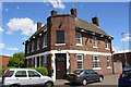
Former Durham Ox pub at junction of Birstall Street and Catherine Street
There is an OS benchmark Image at the middle of the left hand side of the closed public house
Image: © Roger Templeman
Taken: 5 May 2017
0.15 miles
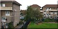
8
Montreal Road in St Matthew's, Leicester
The St Matthew's estate is an inner city area of Leicester. On the right is the Taylor Road Primary School.
Image: © Mat Fascione
Taken: 18 Feb 2020
0.15 miles
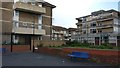
9
Houses on Christow Street
There is an OS benchmark Image on the middle house right of a seat and left of a potted bush.
Image: © Roger Templeman
Taken: 6 Jan 2015
0.15 miles
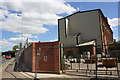
10
Benchmark on #58 Christow Street
Ordnance Survey cut mark benchmark described on the Bench Mark Database at http://www.bench-marks.org.uk/bm63669
Image: © Roger Templeman
Taken: 6 Jan 2015
0.15 miles