IMAGES TAKEN NEAR TO
Ottawa Road, LEICESTER, LE1 2EP
Introduction
This page details the photographs taken nearby to Ottawa Road, LE1 2EP by members of the Geograph project.
The Geograph project started in 2005 with the aim of publishing, organising and preserving representative images for every square kilometre of Great Britain, Ireland and the Isle of Man.

There are currently over 7.5m images from over14,400 individuals and you can help contribute to the project by visiting https://www.geograph.org.uk
Image Map
Images are licensed for reuse under creativecommons.org/licenses/by-sa/2.0
Notes
- Clicking on the map will re-center to the selected point.
- The higher the marker number, the further away the image location is from the centre of the postcode.
Image Listing (76 Images Found)
Images are licensed for reuse under creativecommons.org/licenses/by-sa/2.0
Image
Details
Distance
1
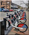
Santander Cycles Leicester
Santander Cycles Leicester is the newest and largest docked e-bike scheme in the UK. It will feature 500 e-bikes at 50 docking stations placed in key locations within the city centre.
This docking station is on Malabar Road, in the St Matthew's area of Leicester.
Image: © Mat Fascione
Taken: 19 Jan 2021
0.06 miles
3
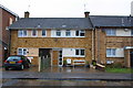
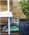
Houses on Christow Street
There is an OS benchmark Image on the middle house right of a seat and left of a potted bush.
Image: © Roger Templeman
Taken: 6 Jan 2015
0.11 miles
4
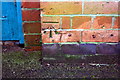
Benchmark on #58 Christow Street
Ordnance Survey cut mark benchmark described on the Bench Mark Database at http://www.bench-marks.org.uk/bm63669
Image: © Roger Templeman
Taken: 6 Jan 2015
0.11 miles
5
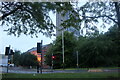
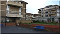
Buildings by St Matthew's Way, Leicester
Image: © David Howard
Taken: 5 Jun 2022
0.12 miles
6
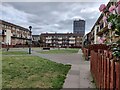
Flats in St Matthew's, Leicester
The St Matthew's estate is an inner city area of Leicester.
Image: © Mat Fascione
Taken: 26 Aug 2021
0.12 miles
7
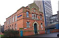
Benchmark on former Zion Chapel, Erskine Street
Ordnance Survey cut mark benchmark described on the Bench Mark Database at http://www.bench-marks.org.uk/bm63439
Image: © Roger Templeman
Taken: 3 Jan 2015
0.13 miles
8
Arnold Street in St Matthew's, Leicester
The St Matthew's estate is an inner city area of Leicester.
Image: © Mat Fascione
Taken: 18 Oct 2019
0.13 miles
9
Former Zion Chapel, Eskine Street
There is an OS benchmark Image on the near corner of the building (now the offices of Bray & Bray Solicitors) right of the blue gate
Image: © Roger Templeman
Taken: 3 Jan 2015
0.13 miles