IMAGES TAKEN NEAR TO
Ottawa Road, LEICESTER, LE1 2EH
Introduction
This page details the photographs taken nearby to Ottawa Road, LE1 2EH by members of the Geograph project.
The Geograph project started in 2005 with the aim of publishing, organising and preserving representative images for every square kilometre of Great Britain, Ireland and the Isle of Man.

There are currently over 7.5m images from over14,400 individuals and you can help contribute to the project by visiting https://www.geograph.org.uk
Image Map
Images are licensed for reuse under creativecommons.org/licenses/by-sa/2.0
Notes
- Clicking on the map will re-center to the selected point.
- The higher the marker number, the further away the image location is from the centre of the postcode.
Image Listing (114 Images Found)
Images are licensed for reuse under creativecommons.org/licenses/by-sa/2.0
Image
Details
Distance
1
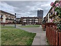
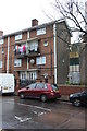
Flats in St Matthew's, Leicester
The St Matthew's estate is an inner city area of Leicester.
Image: © Mat Fascione
Taken: 26 Aug 2021
0.03 miles
2
Manitoba Road in St Matthew's, Leicester
The St Matthew's estate is an inner city area of Leicester.
Image: © Mat Fascione
Taken: 17 Oct 2019
0.04 miles
3
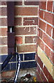
Benchmark on #40 Manitoba Road
Ordnance Survey cut mark benchmark described on the Bench Mark Database at http://www.bench-marks.org.uk/bm63668
Image: © Roger Templeman
Taken: 6 Jan 2015
0.06 miles
4
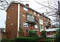
Flats on Manitoba Road
There is an OS benchmark Image on the near corner, road face, of the block of flats
Image: © Roger Templeman
Taken: 6 Jan 2015
0.06 miles
5
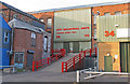
City Industrial Units
Small industrial units to be rented.
Image: © Andrew Tatlow
Taken: 4 Oct 2015
0.06 miles
6
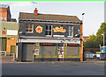
The Musician
The website at http://www.themusicianpub.co.uk/ says "Tucked away in a quiet back street in the heart of Leicester, The Musician is the Midlands premier independent music venue. With live music at least six nights a week, it holds 220 people and features comfortable seating, full disabled access, easy parking and a selection of real ales."
Image: © Andrew Tatlow
Taken: 4 Oct 2015
0.07 miles
7
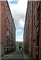
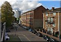
Wheat Street, Leicester
A throwback to Leicester's hosiery heyday. The warehouses probably date from the 1870s, the work of James Bird.
Image: © Stephen Richards
Taken: 24 Aug 2011
0.07 miles
8
Benchmark on #105 Wharf Street
Ordnance Survey cut mark benchmark described on the Bench Mark Database at http://www.bench-marks.org.uk/bm63577
Image: © Roger Templeman
Taken: 6 Jan 2015
0.08 miles
9
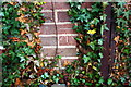
Apartment block on Wharf Street
There is an OS benchmark Image on the front of the block at the near ivy-clad corner behind the fence in this view
Image: © Roger Templeman
Taken: 6 Jan 2015
0.08 miles