IMAGES TAKEN NEAR TO
Chapel Lane, LOUGHBOROUGH, LE12 5AT
Introduction
This page details the photographs taken nearby to Chapel Lane, LE12 5AT by members of the Geograph project.
The Geograph project started in 2005 with the aim of publishing, organising and preserving representative images for every square kilometre of Great Britain, Ireland and the Isle of Man.

There are currently over 7.5m images from over14,400 individuals and you can help contribute to the project by visiting https://www.geograph.org.uk
Image Map
Images are licensed for reuse under creativecommons.org/licenses/by-sa/2.0
Notes
- Clicking on the map will re-center to the selected point.
- The higher the marker number, the further away the image location is from the centre of the postcode.
Image Listing (50 Images Found)
Images are licensed for reuse under creativecommons.org/licenses/by-sa/2.0
Image
Details
Distance
1
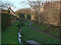
Burton Brook
Running at the back of houses on Melton Road. At the end of this stretch it disappears into a culvert under Brook Road.
Image: © Alan Murray-Rust
Taken: 12 Dec 2011
0.01 miles
2
Sunnyside Pig Farm, Burton on the Wolds
Image: © Chris J Dixon
Taken: 4 Jun 2005
0.02 miles

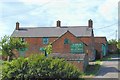
4
Filling station and convenience store, Burton on the Wolds
Image: © David Smith
Taken: 8 Sep 2023
0.03 miles
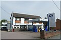
6

Wolds Garage, Burton
Still remaining as an independent fuel outlet. It also doubles as the village shop, and at one time housed the local Post Office, now defunct.
Image: © Alan Murray-Rust
Taken: 12 Dec 2011
0.04 miles
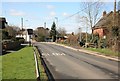
7
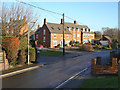
New houses on Melton Road
Part of the substantial modern development based on the new Hubbard Road. The whole development has been designed to fit traditional building styles.
Image: © Alan Murray-Rust
Taken: 12 Dec 2011
0.04 miles
8
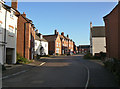
Hubbard Road, Burton
21st century housing development. The houses have been thoughtfully designed using materials and styles to match traditional older housing in the area.
Image: © Alan Murray-Rust
Taken: 12 Dec 2011
0.05 miles
9
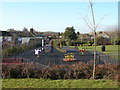
Children's playground, Burton
Situated on the rising ground above Brook Street.
Image: © Alan Murray-Rust
Taken: 12 Dec 2011
0.05 miles
10
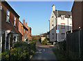
Footpath towards Wymeswold
The traditional alignment of the footpath has been maintained through the new Hubbard Road development. The lower end has been adapted for joint use by cyclists.
Image: © Alan Murray-Rust
Taken: 12 Dec 2011
0.05 miles