IMAGES TAKEN NEAR TO
William Street, LEICESTER, LE1 1RW
Introduction
This page details the photographs taken nearby to William Street, LE1 1RW by members of the Geograph project.
The Geograph project started in 2005 with the aim of publishing, organising and preserving representative images for every square kilometre of Great Britain, Ireland and the Isle of Man.

There are currently over 7.5m images from over14,400 individuals and you can help contribute to the project by visiting https://www.geograph.org.uk
Image Map
Images are licensed for reuse under creativecommons.org/licenses/by-sa/2.0
Notes
- Clicking on the map will re-center to the selected point.
- The higher the marker number, the further away the image location is from the centre of the postcode.
Image Listing (156 Images Found)
Images are licensed for reuse under creativecommons.org/licenses/by-sa/2.0
Image
Details
Distance
1
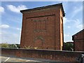
Railway building
This is a building relating to the Leicester station which used to be on the site.
It's incongruous in the middle of a shopping park.
Image: © Dave Thompson
Taken: 21 Jul 2018
0.03 miles
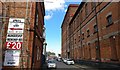
2
Dover Street Car Park Leicester
View from Dover Street, looking towards London Road.
Image: © Terry Roberts
Taken: Unknown
0.07 miles
4
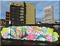
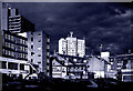
Graffiti along Nichols Street, Leicester
The building on the left is the Phoenix, a cinema and art cafe bar. The tower block on the right is the Cardinal Telephone Exchange Tower, 17 floors and 84 metres in height.
Image: © Mat Fascione
Taken: 7 Dec 2013
0.09 miles
5
Sussex Street in Highfields, Leicester
Image: © Mat Fascione
Taken: 17 Aug 2017
0.10 miles
6
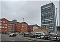
Burton Street in Leicester
On the right is the Cardinal Telephone Exchange Tower, the tallest building in the city of Leicester. It is 84 metres (276 ft) in height, has 17 floors, and was constructed in 1970.
Image: © Mat Fascione
Taken: 1 Mar 2021
0.10 miles
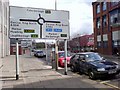
8
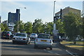
St Georges Way in Leicester
The A594 St Georges Way is part of the inner ring road of Leicester.
Image: © Mat Fascione
Taken: 16 Sep 2019
0.11 miles
9
The end of Humberstone Road
The roundabout is on the ring road, and is the junction between St Matthew's Way and St George's Way.
Image: © Keith Williams
Taken: 27 Mar 2008
0.11 miles
10
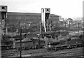
Leicester (London Midland) Locomotive Depot
View NW across the Locomotive Yard and main line to the Goods Station, with Engine Shed Sidings signalbox over on the right: the recently (1945) rebuilt Shed was to the right, London Road Station to the left. The Depot (coded 15C in the Wellingborough District) was large, with an allocation in 1954 of 74 locomotives, comprising 11 4-6-0s, 12 4-4-0s, 7 2-8-0s, 2 2-6-0s, 27 0-6-0s, 1 4-4-2T, 5 2-6-4Ts, 3 2-6-2Ts and 6 0-6-0Ts. These covered much of the passenger and freight work in and around Leicester and on the LMR lines radiating from there, also a number of duties on the main London St Pancras - Sheffield route. (The photograph features 0-6-0s Nos. 43710 and 44522 with 4-6-0s Nos. 44853 and 45137 in the third row). The Depot closed to steam on 13/6/65, but remained in use by Diesels for some years.
Image: © Ben Brooksbank
Taken: 29 Sep 1957
0.11 miles