IMAGES TAKEN NEAR TO
Charnwood Forester End, LOUGHBOROUGH, LE11 5EX
Introduction
This page details the photographs taken nearby to Charnwood Forester End, LE11 5EX by members of the Geograph project.
The Geograph project started in 2005 with the aim of publishing, organising and preserving representative images for every square kilometre of Great Britain, Ireland and the Isle of Man.

There are currently over 7.5m images from over14,400 individuals and you can help contribute to the project by visiting https://www.geograph.org.uk
Image Map (Loading...)


Getting Data...Please wait
Leaflet Map data © OpenStreetMap
Images are licensed for reuse under creativecommons.org/licenses/by-sa/2.0
Notes
- Clicking on the map will re-center to the selected point.
- The higher the marker number, the further away the image location is from the centre of the postcode.
Image Listing (32 Images Found)
Images are licensed for reuse under creativecommons.org/licenses/by-sa/2.0
Image
Details
Distance
1
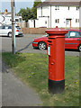
Alan Moss Road postbox ref: LE11 139
Standard EIIR pillar box, but note the remains of the 'Post Office' sign on top. There is no evidence on older maps of a Post Office in the immediate vicinity.
Image: © Alan Murray-Rust
Taken: 16 Apr 2011
0.05 miles
2
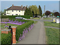
Alyssum hedge
An abundant growth of this pretty violet flower has transformed what would have been a dull privet hedge.
Image: © Alan Murray-Rust
Taken: 16 Apr 2011
0.08 miles
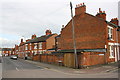
3
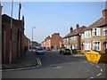
Rosebery Street, Loughborough
Seen from Storer Road.
Image: © Richard Vince
Taken: 28 Sep 2013
0.08 miles
4
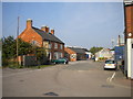
North end of Cumberland Road, Loughborough
Providing access to Cumberland Trading Estate; seen from the end of Rosebery Street.
Image: © Richard Vince
Taken: 28 Sep 2013
0.09 miles
5
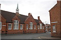
Junction of Storer Road and Havelock Street
There is an OS benchmark Image on the Storer Road face of the building (Rosebery Medical Centre) opposite Havelock Street, about 18m from the far corner of the building.
Image: © Roger Templeman
Taken: 8 Apr 2016
0.09 miles
6
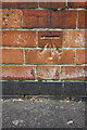
Benchmark on Rosebery Medical Centre, Storer Road face
Ordnance Survey cut mark benchmark described on the Bench Mark Database at http://www.bench-marks.org.uk/bm74825
Image: © Roger Templeman
Taken: 8 Apr 2016
0.10 miles
7
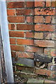
Benchmark on Rosebery Street wall
Ordnance Survey cut mark benchmark described on the Bench Mark Database at http://www.bench-marks.org.uk/bm74824
Image: © Roger Templeman
Taken: 8 Apr 2016
0.10 miles
8
Junction on Rosebery Street and Cumberland Road
There is an OS benchmark Image on the corner of the wall right of the wooden telephone pole
Image: © Roger Templeman
Taken: 8 Apr 2016
0.10 miles
9
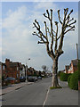
Pollarded plane tree
This type of treatment of trees is less seen these days, as it is labour intensive.
Image: © Alan Murray-Rust
Taken: 16 Apr 2011
0.11 miles
10
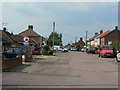
Carington Street
On older maps spelt with two 'r's. This and the two adjacent streets to the west remain unadopted, hence the non-standard road signs. Until Alan Moss Road was constructed they were cul-de-sacs with access from the far end only.
Image: © Alan Murray-Rust
Taken: 16 Apr 2011
0.13 miles