IMAGES TAKEN NEAR TO
LD8 2WG
Introduction
This page details the photographs taken nearby to LD8 2WG by members of the Geograph project.
The Geograph project started in 2005 with the aim of publishing, organising and preserving representative images for every square kilometre of Great Britain, Ireland and the Isle of Man.

There are currently over 7.5m images from over14,400 individuals and you can help contribute to the project by visiting https://www.geograph.org.uk
Image Map
Images are licensed for reuse under creativecommons.org/licenses/by-sa/2.0
Notes
- Clicking on the map will re-center to the selected point.
- The higher the marker number, the further away the image location is from the centre of the postcode.
Image Listing (419 Images Found)
Images are licensed for reuse under creativecommons.org/licenses/by-sa/2.0
Image
Details
Distance
1
![Knighton houses [20]](https://s2.geograph.org.uk/geophotos/06/94/43/6944358_d722f0ec_120x120.jpg)
Knighton houses [20]
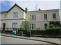
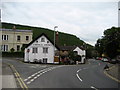
Burford House, number 1 Wylcwm Street, is an early or mid 19th century house. The front is rendered and lined to simulate ashlar, all under a slate roof. Listed, grade II, with details at: https://cadwpublic-api.azurewebsites.net/reports/listedbuilding/FullReport?lang=&id=9030
Knighton is a somewhat remote market town gaining its charter in 1203. It is sited on the River Teme some 60 miles north of Cardiff. It lies on the Welsh/English border, with a small part in Shropshire, including its railway station. Originally an Anglo-Saxon settlement, Knighton is located on Offa's Dyke, the ancient earthwork that divided the two countries. It later became a Norman defensive border town.
Image: © Michael Dibb
Taken: 31 May 2021
0.01 miles
2
Burford House, Knighton
Burford House (on the right) dates from the early nineteenth century https://cadwpublic-api.azurewebsites.net/reports/listedbuilding/FullReport?lang=&id=9030
Image: © Jonathan Thacker
Taken: 1 Jun 2023
0.01 miles
3
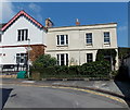
Grade II listed Burford House, Knighton
On the right is Burford House, number 1 Wylcwm Street, built in the typically Georgian rectangular style. Its exact date of construction appears to be unknown, but it is likely to be either late Georgian or early Victorian. Grade II listed in September 1985.
Image: © Jaggery
Taken: 26 Aug 2013
0.01 miles
5
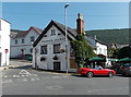
Horse & Jockey, Knighton
A good pub with some local beer, and a separate restaurant which is less noisy. Kinsley Wood dominates the town behind.
Image: © Bill Boaden
Taken: 18 Aug 2017
0.02 miles
6
Station Road, Knighton
Station Road looking north pass the Horse and Jockey - A488 road for Clun and eventually Shrewsbury.
Image: © Chris Heaton
Taken: 18 May 2008
0.02 miles
7
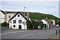
Horse & Jockey, Knighton
On the corner of Station Road and Wylcwm Street. Originally a medieval coaching inn, now a modern inn (pub with accommodation). The restaurant seats 80 people.
Image: © Jaggery
Taken: 26 Aug 2013
0.02 miles
8
![Knighton buildings [6]](https://s0.geograph.org.uk/geophotos/06/93/98/6939832_2d24ef3b_120x120.jpg)
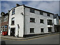
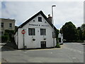
Knighton buildings [6]
The Horse and Jockey public house is sited at the junction of Wylcwm Street, Wylcwm Place and Station Road. The building, in a U shaped courtyard plan, has medieval origins with 18th and 19th century additions and alterations including the incorporation of the former stables. Constructed of rendered brick and whitewashed stone, all under a mixture of slate and tile roofs. Some early internal features remain. Listed, grade II, with details at: https://cadwpublic-api.azurewebsites.net/reports/listedbuilding/FullReport?lang=&id=9029
Knighton is a somewhat remote market town gaining its charter in 1203. It is sited on the River Teme some 60 miles north of Cardiff. It lies on the Welsh/English border, with a small part in Shropshire, including its railway station. Originally an Anglo-Saxon settlement, Knighton is located on Offa's Dyke, the ancient earthwork that divided the two countries. It later became a Norman defensive border town.
Image: © Michael Dibb
Taken: 31 May 2021
0.02 miles
9
The Horse and Jockey, Knighton
Probably dates from the seventeenth century but altered https://cadwpublic-api.azurewebsites.net/reports/listedbuilding/FullReport?lang=&id=9029
Image: © Jonathan Thacker
Taken: 1 Jun 2023
0.02 miles
10

Old Milestone by the A488, Station Road, Knighton
Milestone by the A488, in parish of Knighton (Powys District), Station Road, Knighton, corner of Horse & Jockey PH, in paving.
Inscription reads:-
Clun
7
Surveyed
Milestone Society National ID: RAD_KNCL00
Image: © Milestone Society
Taken: Unknown
0.02 miles