IMAGES TAKEN NEAR TO
Merthyr Cynog, BRECON, LD3 9SD
Introduction
This page details the photographs taken nearby to LD3 9SD by members of the Geograph project.
The Geograph project started in 2005 with the aim of publishing, organising and preserving representative images for every square kilometre of Great Britain, Ireland and the Isle of Man.

There are currently over 7.5m images from over14,400 individuals and you can help contribute to the project by visiting https://www.geograph.org.uk
Image Map
Images are licensed for reuse under creativecommons.org/licenses/by-sa/2.0
Notes
- Clicking on the map will re-center to the selected point.
- The higher the marker number, the further away the image location is from the centre of the postcode.
Image Listing (13 Images Found)
Images are licensed for reuse under creativecommons.org/licenses/by-sa/2.0
Image
Details
Distance
1
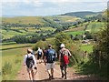
Merthyr Cynog
Cerddwyr yn anelu i lawr o'r ucheldir tuag at bentre bach Merthyr Cynog. Y cwm yn y pellter yw Ysgir Fawr.
Walkers descending towards the tiny village of Merthyr Cynog. The valley in the distance is that of Cwm Ysgir Fawr.
Image: © Alan Richards
Taken: 29 Jul 2012
0.05 miles
2
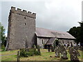
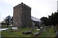
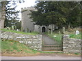
Eglwys Merthyr Cynog / Merthyr Cynog Church
Eglwys Merthyr Cynog a dywedir y sefydlwyd eglwys yma nol yn 5g gan Sant Cynog ei hun. Yn ol traddodiad fe'i llofruddwyd gan y Sacsoniaid. Mae'r eglwys y dyddio o'r 14g ond mae rhannau ohoni yn dyddio yn ol i'r 12g ac mae ganddi dwr enfawr. Yn ystod y Canol Oesoedd bu'eglwys yn fan perindota oherwydd y cedwid torch neu goler Sant Cynog yma.
Merthyr Cynog Church (trans. the shrine of Cynog) dates from the 14th century and parts reputedly date back to the 12th century. It also has a massive tower. A place of worship was probably founded on this site by St Cynog himself in the 5th century. Tradition has it that he was murdered by invading Saxons. During the Middle Ages the church became a place of pilgrimage as it apparently possessed Cynog's torque or collar.
Image: © Alan Richards
Taken: 29 Jul 2012
0.05 miles
4
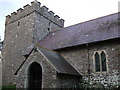
Merthyr Cynog church
Merthyr Cynog church is dedicated to St Cynog and is Grade II* listed. The tower which is squat and broad is of particular note and may date from Norman times.
Image: © Philip Halling
Taken: 7 Mar 2018
0.06 miles
5
Merthyr Cynog church
Merthyr Cynog church is dedicated to St Cynog and is Grade II* listed. The tower which is squat and broad is of particular note and may date from Norman times.
Image: © Philip Halling
Taken: 7 Mar 2018
0.06 miles
6
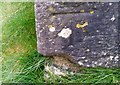
Ordnance Survey Cut Mark
This OS cut mark can be found on the SW angle of St Cynog's Church. It marks a point 319.991m above mean sea level.
Image: © Adrian Dust
Taken: 2 Feb 2017
0.06 miles
7
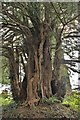
One Of A Few
Merthyr Cynog Church has a number of very old Common Yews on a Site believed to have been Christian for 1500 years. Cynog was the name of the Saint who founded the site and he is believed to be buried within the Churchyard.
Image: © paul wood
Taken: 12 May 2017
0.07 miles
8
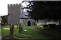
Merthyr Cynog Church
A beautiful old church with an unusual square, castellated tower and a number of scots pines joining the more ubiquitous yew trees in the church yard.
Image: © Dave Pinniger
Taken: 19 Nov 2007
0.07 miles
9
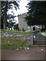
Entrance to the Church of St Cynog at Merthyr Cynog
Image: © Peter Robinson
Taken: 16 Apr 2013
0.07 miles
10
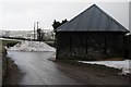
Snow pile at Merthyr Cynog
Snow is still piled high in places on the road here at Merthyr Cynog after last week's heavy snowfall as a result of Storm Emma clashing with the freezing cold wind from Siberia, named by the media the 'Beast from the East'.
Image: © Philip Halling
Taken: 7 Mar 2018
0.08 miles