
IMAGES TAKEN NEAR TO
Middle Lane, KENDAL, LA9 4NR
Introduction
This page details the photographs taken nearby to Middle Lane, LA9 4NR by members of the Geograph project.
The Geograph project started in 2005 with the aim of publishing, organising and preserving representative images for every square kilometre of Great Britain, Ireland and the Isle of Man.

There are currently over 7.5m images from over14,400 individuals and you can help contribute to the project by visiting https://www.geograph.org.uk
Image Map
Images are licensed for reuse under creativecommons.org/licenses/by-sa/2.0
Notes
- Clicking on the map will re-center to the selected point.
- The higher the marker number, the further away the image location is from the centre of the postcode.
Image Listing (361 Images Found)
Images are licensed for reuse under creativecommons.org/licenses/by-sa/2.0
Image
Details
Distance
1

Benchmark on buttress of All Hallows Church House
Ordnance Survey cut mark benchmark levelled at 70.070m above Newlyn Datum verified in 1972
Image: © Roger Templeman
Taken: 28 Jul 2010
0.02 miles
2

Fellside Methodist Church, Low Fellside
A carved inscription at the top of the building says : PRIMITIVE METHODIST MISSION HALL. 1899. JOB PENNINGTON'S MEMORIAL.
The church has an adjacent hall (wall on left), which is available for hire http://www.kendalmethodistcircuit.org.uk/fellside/ .
Image: © Rose and Trev Clough
Taken: 19 Apr 2016
0.02 miles
3
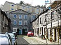
The Old Shambles
View towards the end of a lane (or yard) off Highgate, which starts beside Ye Olde Fleece Inn (photo http://www.geograph.org.uk/photo/3434709 ).
The Old Shambles was built in 1779 to house the town's butchers. Animals were slaughtered in the street but the site was badly drained, so must have been quite unpleasant even by the standards of the day. After only 25 years the butchers moved to the 'New Shambles' in the Market Place. The butchers' shops have since been converted to dwellings.
The taller building at the head of the yard was originally The Butcher's Arms pub, which was later used as a dye factory and a warehouse. Today it appears to be in residential use. It is a listed building http://www.imagesofengland.org.uk/details/default.aspx?id=75472 .
Historical information from walk booklet by Kendal Civic Society.
Image: © Rose and Trev Clough
Taken: 19 Apr 2016
0.04 miles
4

Junction on Sepulchre Lane and Low Fellside
The steps lead to The Fellside Centre. There is an Ordnance Survey benchmark Image on the wall on the right hand side of Sepulchre Lane at its end (facing into the Lane)
Image: © Roger Templeman
Taken: 23 Jul 2022
0.05 miles
5

Benchmark on #33 Low Fellside
Ordnance Survey cut mark benchmark levelled at 61.550m above Newlyn Datum verified 1972
Image: © Roger Templeman
Taken: 28 Jul 2010
0.05 miles
6

The Quaker Burial Ground off Sepulchre Lane, Kendal
It was first used in 1656. In 1855 it was closed to burials and part was made a garden in 1863. Three of the gravestones have been incorporated into the wall. Two of them are visible in the picture.
Image: © Tim Hodgins
Taken: 17 Oct 2013
0.05 miles
7

Quiggin's Kendal mint cake factory
Located in Low Fellside. Quiggins have been making Kendal mint cake since 1880 https://www.quiggins.co.uk/ . Today they also produce a range of other confectionery.
Image: © Rose and Trev Clough
Taken: 19 Apr 2016
0.05 miles
8

Benchmark on wall of Sepulchre Lane
Ordnance Survey cut mark benchmark described on the Bench Mark Database at http://www.bench-marks.org.uk/bm34979 . There is a close-up of the mark at Image
Image: © Roger Templeman
Taken: 28 Jul 2010
0.06 miles
9

Ordnance Survey Cut Mark
This OS cut mark can be found at the junction of Sepulchre Lane & Low Fellside. It marks a point 61.480m above mean sea level.
Image: © Adrian Dust
Taken: 22 Oct 2023
0.06 miles
10

Benchmark on north side of Sepulchre Lane at its east end
Ordnance Survey cut mark benchmark levelled at 61.480m above Newlyn Datum verified 1971
Image: © Roger Templeman
Taken: 23 Jul 2022
0.06 miles