IMAGES TAKEN NEAR TO
LA9 4EE
Introduction
This page details the photographs taken nearby to LA9 4EE by members of the Geograph project.
The Geograph project started in 2005 with the aim of publishing, organising and preserving representative images for every square kilometre of Great Britain, Ireland and the Isle of Man.

There are currently over 7.5m images from over14,400 individuals and you can help contribute to the project by visiting https://www.geograph.org.uk
Image Map
Images are licensed for reuse under creativecommons.org/licenses/by-sa/2.0
Notes
- Clicking on the map will re-center to the selected point.
- The higher the marker number, the further away the image location is from the centre of the postcode.
Image Listing (431 Images Found)
Images are licensed for reuse under creativecommons.org/licenses/by-sa/2.0
Image
Details
Distance
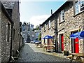
1
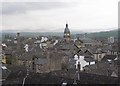
Kendal roofscape
The buildings of Kendal, especially on the west side of the main street, are very tightly packed, with access from narrow 'yards', many with no name but identified by numbers. The two prominent features are the chimney of the former public baths and the tower of the Town Hall.
Image: © Humphrey Bolton
Taken: 7 May 2006
0.00 miles
2
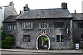
Sandes Hospital, Kendal
With a datestone of 1659. "In this yard, Thomas Sandes (1606-1681), cloth merchant and former Mayor of Kendal, founded a school and eight almshouses for poor widows", (Kendal Civic Society). Within the gateway is an old iron collecting box carrying the inscription "Remember the Poor".
Image: © David Rogers
Taken: 14 Aug 2010
0.00 miles
3
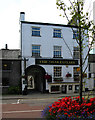
The Shakespeare, Kendal
The Shakespeare was first offered to let in 1858, and was described as “a Kendal house known by the name of The Shakespeare Tavern with brew house, stables and hayloft”. Throughout the years it has been known as an inn, a tavern and a hotel. The pub sits at the entrance to the old Shakespeare Theatre which closed in 1930’s.
Image: © David Rogers
Taken: 14 Aug 2010
0.00 miles
5
Shakespeare Yard
The Shakespeare Hotel is on the right. The building at the end of the yard was originally the Shakespeare Theatre, which opened in 1829 but closed after just five years. It later became a ballroom, then a warehouse. In the 1990s it was converted to a church, now known as The Shakespeare Centre.
Image: © Rose and Trev Clough
Taken: 19 Apr 2016
0.02 miles
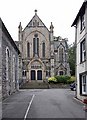
6
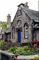
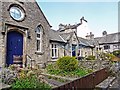
Sandes Hospital Cottages off Highgate
Grade II Listed row of cottages originally of 1659 or 1663 by Thomas Sandes, cotton dealer and mayor 1647-48, rebuilt 1852. The gatehouse dated on a 19th century panel as 1659 is incorrect; a late 17th century drawing shows the date as 1663.
Image: © Jo and Steve Turner
Taken: 28 May 2000
0.02 miles
7
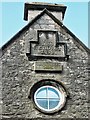
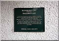
Datestones, Sandes Hospital almshouses
Located on the gable of the building shown here Image .
Image: © Rose and Trev Clough
Taken: 19 Apr 2016
0.02 miles
8
Sandes' Hospital Cottages
Grade II listed buildings forming one of the many yards in Kendal
Image: © Kevin Waterhouse
Taken: 30 Aug 2012
0.02 miles
10
Sandes Hospital almshouses
The almshouses for poor widows were founded in 1659 by Thomas Sandes, a wealthy woollen merchant. The cottages were rebuilt in 1852 by Miles Thompson, a Kendal architect, and refurbished in 1993. There are plaques recording these dates in the gable of the cottage on the left, which is the former library - see Image .
The dwellings are grade II listed. See Images of England http://www.imagesofengland.org.uk/details/default.aspx?id=75399 for architectural details, also photo taken in 2001 when the chimneys were much taller.
Image: © Rose and Trev Clough
Taken: 19 Apr 2016
0.03 miles