
IMAGES TAKEN NEAR TO
Market Place, DALTON-IN-FURNESS, LA15 8AX
Introduction
This page details the photographs taken nearby to Market Place, LA15 8AX by members of the Geograph project.
The Geograph project started in 2005 with the aim of publishing, organising and preserving representative images for every square kilometre of Great Britain, Ireland and the Isle of Man.

There are currently over 7.5m images from over14,400 individuals and you can help contribute to the project by visiting https://www.geograph.org.uk
Image Map
Images are licensed for reuse under creativecommons.org/licenses/by-sa/2.0
Notes
- Clicking on the map will re-center to the selected point.
- The higher the marker number, the further away the image location is from the centre of the postcode.
Image Listing (73 Images Found)
Images are licensed for reuse under creativecommons.org/licenses/by-sa/2.0
Image
Details
Distance
1
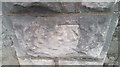
Ordnance Survey Cut Mark
This OS cut mark can be found on the gatepost of No18 Market Place. It marks a point 44.878m above mean sea level.
Image: © Adrian Dust
Taken: 15 Oct 2019
0.02 miles
2
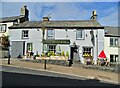
"The Red Lion" in Dalton
On Market Street
Image: © Neil Theasby
Taken: 18 Sep 2022
0.03 miles
3
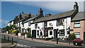
The Red Lion public house on Market Street
Image: © Stephen Middlemiss
Taken: 2 Jul 2010
0.03 miles
4
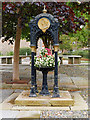
Queen Victoria Diamond Jubilee Drinking Fountain
Erected in the market place in 1887 to celebrate Queen Victoria's Diamond Jubilee. The rear roundel depicts Queen Victoria and the fountain is inscribed 'ERECTED IN MEMORY OF HER MAJESTYS DIAMOND JUBILEE' above the motto 'KEEP THE PAVEMENT DRY'. Now being used to house bedding plants.
Grade II-listed (https://historicengland.org.uk/listing/the-list/list-entry/1197833 Historic England List Entry Number: 1197833)
Image: © David Dixon
Taken: 27 Aug 2020
0.03 miles
5
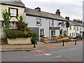
Dalton-in-Furness, The Red Lion Hotel
The Red Lion Hotel on Market Street, dated from the late seventeenth century. It is a Grade II listed building (https://historicengland.org.uk/listing/the-list/list-entry/1283053 Historic England List Entry Number: 1283053).
Image: © David Dixon
Taken: 27 Aug 2020
0.03 miles
6
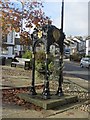
Former drinking fountain, Market Place, Dalton-in-Furness
What was once a working drinking fountain in Market Place, Dalton. The fountain was erected in 1897 to commemorate the diamond jubilee of the reign of Queen Victoria. The fountain is no longer functioning and the central bowl has been reused as a planter. The fountain is grade II listed, English Heritage listing text here: http://list.english-heritage.org.uk/resultsingle.aspx?uid=1197833 An identical fountain can be found nearby in Askam-in-Furness Image
Image: © Graham Robson
Taken: 3 Nov 2014
0.03 miles
7
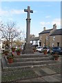
Market Cross, Dalton-in-Furness
The Market Cross in Market Square in Dalton, at the western end of Market Street. The cross dates from 1869-70 and is grade II listed. English Heritage listing text here: http://list.english-heritage.org.uk/resultsingle.aspx?uid=1197834
Image: © Graham Robson
Taken: 3 Nov 2014
0.04 miles
9
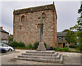
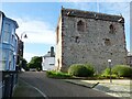
Dalton-in-Furness, Market Cross and Castle
The limestone market cross dates from 1869-70 and stands in front of Dalton Castle, on the site of an earlier cross. The cross is Grade II-listed (https://historicengland.org.uk/listing/the-list/list-entry/1197834 Historic England List Entry Number: 1197834).
Dalton Castle is a 14th-century peel tower situated in the Market Place at Dalton-in-Furness. It was constructed by the monks of Furness Abbey for the protection of the nearby market town and was the building from which the Abbot administered the area and dispensed justice. It was used as a prison between 1257 and 1774.
The castle is a Grade I Listed building (https://historicengland.org.uk/listing/the-list/list-entry/1218342 Historic England List Entry Number: 1218342) and a scheduled ancient monument (https://historicengland.org.uk/listing/the-list/list-entry/1020457 List Entry Number: 1020457). It is owned by the National Trust.
Image: © David Dixon
Taken: 27 Aug 2020
0.04 miles
10
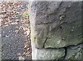
Ordnance Survey Cut Mark
This OS cut mark can be found on the garage at the rear of The White Horse. It marks a point 38.274m above mean sea level.
Image: © Adrian Dust
Taken: 15 Oct 2019
0.04 miles