
IMAGES TAKEN NEAR TO
Lindale, GRANGE-OVER-SANDS, LA11 6NA
Introduction
This page details the photographs taken nearby to LA11 6NA by members of the Geograph project.
The Geograph project started in 2005 with the aim of publishing, organising and preserving representative images for every square kilometre of Great Britain, Ireland and the Isle of Man.

There are currently over 7.5m images from over14,400 individuals and you can help contribute to the project by visiting https://www.geograph.org.uk
Image Map
Images are licensed for reuse under creativecommons.org/licenses/by-sa/2.0
Notes
- Clicking on the map will re-center to the selected point.
- The higher the marker number, the further away the image location is from the centre of the postcode.
Image Listing (13 Images Found)
Images are licensed for reuse under creativecommons.org/licenses/by-sa/2.0
Image
Details
Distance

2
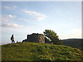
Ruined tower on top of Dixon Heights, Newton Fell
A.Wainwright in his 'Outlying Fells' volume states that the tower was: 'habitable and used by the Home Guard during the last war. The origins and purpose of the tower are obscure. There is a legend that it was a lookout for the observation of smugglers in the estuary but it seems equally likely to have been merely a decoration of the Eller How estate, this theory being supported by the presence of other ornamental stonework in the vicinity.'. The Heights are now CRoW access land and accessible via public footpath. It is well worth the small exertion for the wide-ranging views.
Image: © Karl and Ali
Taken: 5 Sep 2012
0.16 miles
4
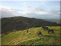
Confrontation on Dixon Heights
As I stood on top of the tower a group of dark ponies advanced towards Ali. What could I honestly do against this combined might of horse flesh? I might as well take pictures (which might prove useful at the inquest) rather than die in a brave but possibly futile attempt at rescue. In the end, the equines decided they'd rather eat some grass than trample Ali into the ground. Dixon Heights (177m or 178m depending on whichever scale of map) is one of the last summits at the southern end of the long ridge of Newton Fell, seen here extending to the north. Much of it is now CRoW access land and can be reached via public footpaths although we did have to climb over one drystone wall to reach the top of Raven Scar. The paths below the open grassy top of the Heights were quite churned up either by cattle or these ponies.
Image: © Karl and Ali
Taken: 5 Sep 2012
0.18 miles
5
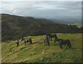
Confrontation on Dixon Heights - the crisis develops
As I stood on top of the tower a group of dark ponies advanced towards Ali. What could I honestly do against this combined might of horse flesh? I might as well take pictures (which might prove useful at the inquest) rather than die in a brave but possibly futile attempt at rescue. In the end, the equines decided they'd rather eat some grass than trample Ali into the ground. Dixon Heights (177m or 178m depending on whichever scale of map) is one of the last summits at the southern end of the long ridge of Newton Fell, seen here extending to the north. Much of it is now CRoW access land and can be reached via public footpaths although we did have to climb over one drystone wall to reach the top of Raven Scar. The paths below the open grassy top of the Heights were quite churned up either by cattle or these ponies.
Image: © Karl and Ali
Taken: 5 Sep 2012
0.18 miles
6
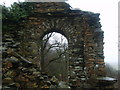
Old Gateway
Crumbling gateway in a very substantial old wall which surrounds woodland above Eller How.
Image: © Michael Graham
Taken: 18 Jan 2010
0.18 miles
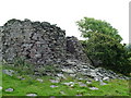
8

Tower on Newton Fell
On the top of this Outlying Wainwright. The ruin can be seen from the A590 road as it climbs Lindale Hill.
Image: © Michael Graham
Taken: 18 Jan 2010
0.19 miles
9

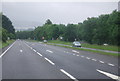
The A590 at Eller How
About 2.5 miles of the A590, from here to Whitestone, was upgraded to dual carriageway in 2008.
Image: © David Purchase
Taken: 25 Mar 2017
0.19 miles
10

Old Milestone by the A590, Lindale Brow, Upper Allithwaite parish
Carved stone post by the A590, in parish of UPPER ALLITHWAITE (SOUTH LAKELAND District), by bridge to Moss End Farm, Lindale bypass, on grass verge, on West side of road. Lancs. CC stone triangle, erected by the County Council in the 19th/20th century.
Inscription reads:-
: TO / ULVERSTON 13 MLS / BARROW 21¼ : : ALLITHWAITE / UPPER : : TO / GRANGE 2¾ MLS / KENDAL 13 / LANCASTER 24 :
Milestone Society National ID: LA_LABA24.
Image: © CF Smith
Taken: 28 Oct 2010
0.21 miles