IMAGES TAKEN NEAR TO
L41 6PR
Introduction
This page details the photographs taken nearby to L41 6PR by members of the Geograph project.
The Geograph project started in 2005 with the aim of publishing, organising and preserving representative images for every square kilometre of Great Britain, Ireland and the Isle of Man.

There are currently over 7.5m images from over14,400 individuals and you can help contribute to the project by visiting https://www.geograph.org.uk
Image Map
Images are licensed for reuse under creativecommons.org/licenses/by-sa/2.0
Notes
- Clicking on the map will re-center to the selected point.
- The higher the marker number, the further away the image location is from the centre of the postcode.
Image Listing (213 Images Found)
Images are licensed for reuse under creativecommons.org/licenses/by-sa/2.0
Image
Details
Distance
1
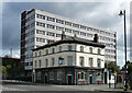
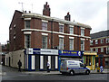
Stork Hotel, Price Street, Birkenhead
An early Victorian pub distinguished by an excellent ground floor of c1903 (Image]). Grade II listed.
Behind is the 1960s Hordan House, currently offices of the Department for Work and Pensions.
Image: © Stephen Richards
Taken: 20 Aug 2014
0.03 miles
2
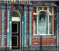
Detail of Stork Hotel, Price Street, Birkenhead
Very fine decorative scheme, dated c1903, Art Nouveau in character.
Wider view: Image
Image: © Stephen Richards
Taken: 20 Aug 2014
0.03 miles
3
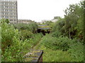
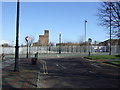
Former Railway Cutting
A railway cutting for the former Birkenhead Dock branch of the Wirral Lines, which runs right through Birkenhead from Bidston to near Rock Ferry.
Image: © David Quinn
Taken: 19 Jul 2008
0.05 miles
4
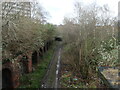
Former docklands railway, Birkenhead
Looking over the bridge parapet on Price Street.
Image: © Christine Johnstone
Taken: 16 Mar 2023
0.05 miles
5
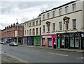
28-50 Argyle Street, Birkenhead
Terraces of flats and shops built c1840-50. Grade II listed.
Image: © Stephen Richards
Taken: 20 Aug 2014
0.08 miles
6
Market Street, Birkenhead
This was transformed some years ago from one of Birkenhead's most run down streets to one which is attractive and bustling. As the name suggests, the road originally led to the old market which was fire damaged in 1969 and 1974, see http://www.birkenheadmarket.co.uk/index.asp?page=3
However, the first market was actually in the space where the Wirral Museum (old town hall) is.
Image: © Peter Craine
Taken: 6 Oct 2006
0.09 miles
7
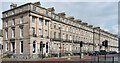
19-34 Hamilton Square, Birkenhead
This remarkably grand and complete Georgian composition is like an alien intrusion into the cityscape. Take one step outside in pretty much any direction and one is brought down to earth with a bump. The rest of William Laird's scheme never got off the ground. The square was laid out by James Gillespie Graham and construction took almost twenty years. The west side, pictured here, was built in 1839-44. Grade I listed.
Image: © Stephen Richards
Taken: 20 Aug 2014
0.09 miles
8
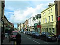
Argyle Street
Looking towards Hamilton Square.
This was originally the centre of the commercial/retail heart of Birkenhead - the renowned Birkenhead Market was a couple of blocks to the right, but the retail centre gradually migrated to the south west with the development of Grange Road and latterly the Grange Centre.
Image: © Alan Murray-Rust
Taken: 5 Oct 2008
0.09 miles
9
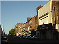
29-33 Argyle Street, Birkenhead
Probably c1840. The rounded corners and parapet lift it up a notch or two.
Shops at the time were Birkenhead Computer Repairs and Argyle News.
Image: © Stephen Richards
Taken: 20 Aug 2014
0.09 miles
10
Europa Boulevard
Junction with Price Street.
Image: © JThomas
Taken: 1 Mar 2014
0.10 miles