IMAGES TAKEN NEAR TO
Durham Wynd, LEVEN, KY8 6DL
Introduction
This page details the photographs taken nearby to Durham Wynd, KY8 6DL by members of the Geograph project.
The Geograph project started in 2005 with the aim of publishing, organising and preserving representative images for every square kilometre of Great Britain, Ireland and the Isle of Man.

There are currently over 7.5m images from over14,400 individuals and you can help contribute to the project by visiting https://www.geograph.org.uk
Image Map
Images are licensed for reuse under creativecommons.org/licenses/by-sa/2.0
Notes
- Clicking on the map will re-center to the selected point.
- The higher the marker number, the further away the image location is from the centre of the postcode.
Image Listing (314 Images Found)
Images are licensed for reuse under creativecommons.org/licenses/by-sa/2.0
Image
Details
Distance
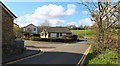
1
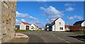
Selkirk Grove, Lower Largo
From Durham Gardens we look across Durham Wynd to Castaway Lane, the entrance to the new housing development of Selkirk Grove, which is still under construction.
See Lower Largo articlehttps://www.geograph.org.uk/article/Lower-Largo-and-the-Serpentine-Walk
Image: © Bill Kasman
Taken: 9 Apr 2019
0.03 miles
2
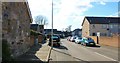
Durham Gardens, Lower Largo
See Lower Largo articlehttps://www.geograph.org.uk/article/Lower-Largo-and-the-Serpentine-Walk
Image: © Bill Kasman
Taken: 9 Apr 2019
0.03 miles
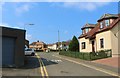
3
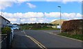
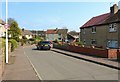
Durham Wynd, Lower Largo
The turning to the left is Durham Gardens and that to the right is Castaway Lane, the entrance to the new housing development of Selkirk Grove which is still under construction. The hill is Largo Law.
See Lower Largo articlehttps://www.geograph.org.uk/article/Lower-Largo-and-the-Serpentine-Walk
Image: © Bill Kasman
Taken: 9 Apr 2019
0.03 miles
4
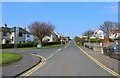
Durham Wynd, Lower Largo
The turning to the left is Station Park.
See Lower Largo article https://www.geograph.org.uk/article/Lower-Largo-and-the-Serpentine-Walk
Image: © Bill Kasman
Taken: 8 Apr 2019
0.05 miles
5
Durham Crescent, Lower Largo
See Lower Largo article https://www.geograph.org.uk/article/Lower-Largo-and-the-Serpentine-Walk
Image: © Bill Kasman
Taken: 8 Apr 2019
0.06 miles
6
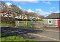
Children's playpark
In Durham Wynd next to Durham Hall, Lower Largo is this children's playpark.
See Lower Largo article https://www.geograph.org.uk/article/Lower-Largo-and-the-Serpentine-Walk
Image: © Bill Kasman
Taken: 9 Apr 2019
0.06 miles
7
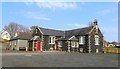
Durham Hall, Lower Largo
Originally built in the 1890s as a school Durham Hall was acquired by Largo St. David's Church in 1957 and now serves as a church and community hall.
See Lower Largo articlehttps://www.geograph.org.uk/article/Lower-Largo-and-the-Serpentine-Walk
Image: © Bill Kasman
Taken: 8 Apr 2019
0.07 miles
8
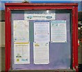
Notice Board
This notice board is at Durham Hall, Lower Largo Image
See Lower Largo articlehttps://www.geograph.org.uk/article/Lower-Largo-and-the-Serpentine-Walk
Image: © Bill Kasman
Taken: 9 Apr 2019
0.07 miles
9
Donaldson's Court, Lower Largo
The turning to the left is Donaldson's Court, a small cul-de-sac off Durham Wynd just before its junction with the A915.
See Lower Largo articlehttps://www.geograph.org.uk/article/Lower-Largo-and-the-Serpentine-Walk
Image: © Bill Kasman
Taken: 9 Apr 2019
0.08 miles
10
Durham Wynd, Lower Largo
See Lower Largo article https://www.geograph.org.uk/article/Lower-Largo-and-the-Serpentine-Walk
Image: © Bill Kasman
Taken: 8 Apr 2019
0.08 miles