IMAGES TAKEN NEAR TO
Southfield, ST. ANDREWS, KY16 8AF
Introduction
This page details the photographs taken nearby to Southfield, KY16 8AF by members of the Geograph project.
The Geograph project started in 2005 with the aim of publishing, organising and preserving representative images for every square kilometre of Great Britain, Ireland and the Isle of Man.

There are currently over 7.5m images from over14,400 individuals and you can help contribute to the project by visiting https://www.geograph.org.uk
Image Map
Images are licensed for reuse under creativecommons.org/licenses/by-sa/2.0
Notes
- Clicking on the map will re-center to the selected point.
- The higher the marker number, the further away the image location is from the centre of the postcode.
Image Listing (164 Images Found)
Images are licensed for reuse under creativecommons.org/licenses/by-sa/2.0
Image
Details
Distance
1
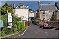
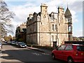
Wallace Street, St Andrews
View from the Bassaguard Industrial estate down the now blocked off Wallace Street to the west end of Kinnessburn Road at its junction with Largo Road.
Or the rear of the Kinnessburn chip shop which ever you prefer.
Image: © Jim Bain
Taken: 14 Jun 2008
0.02 miles
2
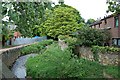
Kinness Burn, St Andrews
Looking north up the Kinness Burn from Kinnessburn Road by Dempster Crescent.
Image: © Jim Bain
Taken: 21 May 2006
0.05 miles
3
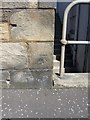
OS benchmark - St Andrews, Maggie Murray's bridge
An OS cutmark on the bridge parapet; originally levelled at 8.025m above Ordnance Datum Newlyn.
Image: © Richard Law
Taken: 9 Jun 2015
0.05 miles
4
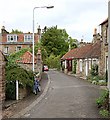
Fleming Place, St Andrews
Looking north down Fleming Place from its junction with Kinnessburn Road.
Image: © Jim Bain
Taken: 21 May 2006
0.05 miles
5
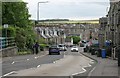
Bridge Street, St Andrews
Looking south along the A915.
Image: © Richard Sutcliffe
Taken: 21 May 2019
0.05 miles
6
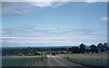
Approaching St. Andrews
Approaching St. Andrews on the A915. I think this photo was taken from the road where the Cairnsmill Caravan Park is today, close to the today's sign "Welcome to St. Andrews".
Image: © Klaus Liphard
Taken: 20 Jul 1974
0.07 miles
7
Ladebraes, St Andrews
From Queens Terrace looking north and down the steep brae to the Kinness burn and Kinnessburn Road
Image: © Jim Bain
Taken: 1 Apr 2006
0.09 miles
8
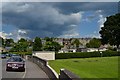
Pipeland Road
The north end of Pipeland Road by the bowling club.
Image: © Jim Bain
Taken: 19 Jun 2012
0.09 miles
9
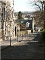
Queens Terrace, St Andrews
From the west end of the terrace by the Madras school gates looking east.
Image: © Jim Bain
Taken: 1 Apr 2006
0.10 miles
10
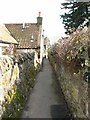
Loudens Close, St Andrews
Looking south back down towards Ladebraes Walk from about midway down the close.
Image: © Jim Bain
Taken: 1 Apr 2006
0.10 miles