IMAGES TAKEN NEAR TO
Quarry Brae, KIRKCALDY, KY1 3AT
Introduction
This page details the photographs taken nearby to Quarry Brae, KY1 3AT by members of the Geograph project.
The Geograph project started in 2005 with the aim of publishing, organising and preserving representative images for every square kilometre of Great Britain, Ireland and the Isle of Man.

There are currently over 7.5m images from over14,400 individuals and you can help contribute to the project by visiting https://www.geograph.org.uk
Image Map
Images are licensed for reuse under creativecommons.org/licenses/by-sa/2.0
Notes
- Clicking on the map will re-center to the selected point.
- The higher the marker number, the further away the image location is from the centre of the postcode.
Image Listing (8 Images Found)
Images are licensed for reuse under creativecommons.org/licenses/by-sa/2.0
Image
Details
Distance
1
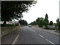
Windmill Road (B928), Dysart
Looking towards the railway bridge.
Image: © JThomas
Taken: 21 Jul 2021
0.21 miles
2
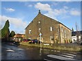
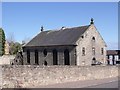
Barony Church, Dysart
Now a block of residential flats, this was once Barony Church and there is an old graveyard at the back with many toppled and broken graves. There is an Ordnance Survey benchmark on this building. See Image
Image: © Becky Williamson
Taken: 8 Dec 2019
0.22 miles
3
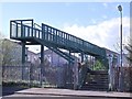
Footbridge to Cameron Drive
Cameron Drive is the new name for Bellfield Crescent. Bellfield Crescent, a.k.a. "Battlefield Crescent" became infamous in the 1980s as a dumping ground for "problem" families. The council houses have now mostly been demolished and replaced by a new development by Muir Homes.
Image: © Ian Calderwood
Taken: 28 Apr 2012
0.22 miles
4
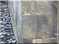
Benchmark on Barony Church, Dysart
Ordnance Survey benchmark on former Barony Church in Dysart. See also Image
Image: © Becky Williamson
Taken: 8 Dec 2019
0.22 miles
5
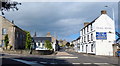
The Barony Church
The Barony was built in 1802. It closed as a church in 1972, when the congregation was merged with that of St Serf's, nearby. It became a YMCA for a while but is now disused and semi-derelict.
Image: © Ian Calderwood
Taken: 28 Apr 2012
0.23 miles
7
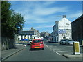
Royal Hotel in Dysart
Along the A955 Townhead at the junction with Windmill Road.
Image: © Mat Fascione
Taken: 22 Jul 2019
0.24 miles
8
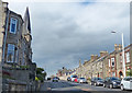
A955 in Dysart
On the left is the crooked spire of the Normand Road United Free Church.
Image: © Mat Fascione
Taken: 22 Jul 2019
0.25 miles