IMAGES TAKEN NEAR TO
Loughrigg, DUNFERMLINE, KY11 8TR
Introduction
This page details the photographs taken nearby to Loughrigg, KY11 8TR by members of the Geograph project.
The Geograph project started in 2005 with the aim of publishing, organising and preserving representative images for every square kilometre of Great Britain, Ireland and the Isle of Man.

There are currently over 7.5m images from over14,400 individuals and you can help contribute to the project by visiting https://www.geograph.org.uk
Image Map
Images are licensed for reuse under creativecommons.org/licenses/by-sa/2.0
Notes
- Clicking on the map will re-center to the selected point.
- The higher the marker number, the further away the image location is from the centre of the postcode.
Image Listing (20 Images Found)
Images are licensed for reuse under creativecommons.org/licenses/by-sa/2.0
Image
Details
Distance
1
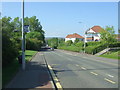
Bus stop on Masterton Road, Dunfermline
National Cycle Route 1 looking north west.
Image: © JThomas
Taken: 25 May 2017
0.03 miles
3
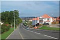
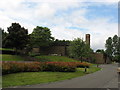
Dunfermline, Masterton looking North
View North with Dunfermline crematorium in trees forward left, Queen Margaret district general hospital white building in distance to right of centre. Duloch housing sprouting to the right.
Image: © Bob Allan
Taken: 12 Sep 2005
0.06 miles
5
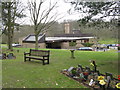
Dunfermline Crematorium
In pleasant wooded surroundings.
Image: © M J Richardson
Taken: 25 Mar 2013
0.12 miles
6
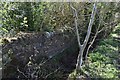
Old Stone Wall
Probably a former field boundary lost in the underground at the junction of Masterton Road and Carnegie Avenue.
Image: © Robert Struthers
Taken: 19 Apr 2020
0.12 miles
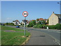
9
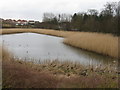
Pond on Masterton Road
Once in splendid isolation, but now surrounded by new housing.
Image: © M J Richardson
Taken: 25 Mar 2013
0.14 miles
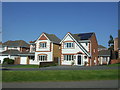
10
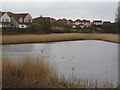
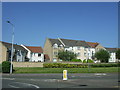
New houses at Dover Heights
Looking over the pond on Masterton Road.
Image: © M J Richardson
Taken: 25 Mar 2013
0.15 miles