IMAGES TAKEN NEAR TO
Morrison Drive, DUNFERMLINE, KY11 8DJ
Introduction
This page details the photographs taken nearby to Morrison Drive, KY11 8DJ by members of the Geograph project.
The Geograph project started in 2005 with the aim of publishing, organising and preserving representative images for every square kilometre of Great Britain, Ireland and the Isle of Man.

There are currently over 7.5m images from over14,400 individuals and you can help contribute to the project by visiting https://www.geograph.org.uk
Image Map
Images are licensed for reuse under creativecommons.org/licenses/by-sa/2.0
Notes
- Clicking on the map will re-center to the selected point.
- The higher the marker number, the further away the image location is from the centre of the postcode.
Image Listing (9 Images Found)
Images are licensed for reuse under creativecommons.org/licenses/by-sa/2.0
Image
Details
Distance
1
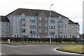
Dover Gardens Dunfermline
Flats at Dover Gardens Dunfermline.
Image: © edward mcmaihin
Taken: 16 Feb 2010
0.12 miles
2
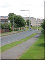
Aberdour Road
Looking eastwards to a new roundabout and the massive housing developments beyond. These fill the gap between the town and the M90.
Image: © Richard Webb
Taken: 19 Jun 2008
0.14 miles
3
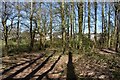
North Wood and Pitcorthie
The houses of Pitcorthie estate visible through the trees of North Wood.
Image: © Robert Struthers
Taken: 19 Apr 2020
0.15 miles
4
New houses, east of Dunfermline
Looking across the Aberdour Road towards some of the many new houses that have recently been built and are still being built in Dunfermline.
Image: © Richard Webb
Taken: 19 Jun 2008
0.16 miles
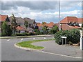
5
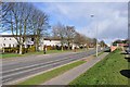
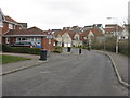
Aberdour Road
Looking east along Aberdour Road.
Image: © Robert Struthers
Taken: 3 Apr 2011
0.16 miles
6
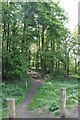
North Wood, Dunfermline.
Footpath to the North Wood at Pitcorthie.
Image: © edward mcmaihin
Taken: 21 May 2010
0.17 miles
7
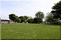
Trees at McKay Drive,Dunfermline.
Trees and grassland at the side of McKay Drive between Kinnis and Russell Courts.
Image: © edward mcmaihin
Taken: 21 May 2010
0.18 miles
8
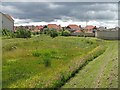
Flood defences
A wildflower meadow now, but this is an area designed to fill and hold surplus run off from the new housing developments to the east of Dunfermline.
Image: © Richard Webb
Taken: 19 Jun 2008
0.22 miles
9
New housing at Dover Drive
Leading to Dover Heights, open land not so long ago.
Image: © M J Richardson
Taken: 25 Mar 2013
0.24 miles